Hurricane Harvey made landfall just after 10 pm CDT Friday night as a powerful category 4 storm packing winds of 140 mph. The storm continued to weaken and now has 75 mph maximum sustained winds. Its track is troubling for the area from Matagorda Bay to the Houston Ship Channel and areas inland due to the flooding rain threat. 275,000 are without electricity in the area from Corpus Christi to Houston.
Get the latest on Harvey on our Storm Page
All available live streams, videos, and broadcasts will be made available HERE.
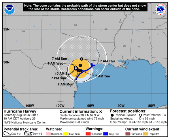
National Weather Service update 8-26-17 – 09:00 CDT: (for our complete Harvey coverage, visit our Harvey page)
Harvey was last reported at 28.9N, 97.3W moving north-northwest at 6 mph with maximum sustained winds of 75 mph. The estimated minimum central pressure based on data from NOAA and Air Force Hurricane Hunter aircraft is 982 mb (29.00 inches) and rising indicating weakening.
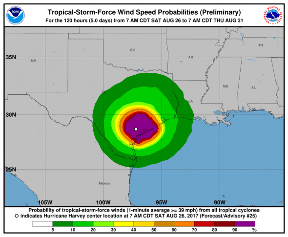
Where will Harvey Go Next
Harvey will continue northwest for another 36 hours or so before turning around on its own track which will keep the storm in the same area for almost 5 days dumping 6 feet or more of rain on the area northwest of Victoria. By the time Harvey exits this area, it will have weakened to a tropical depression and head off to the northeast.
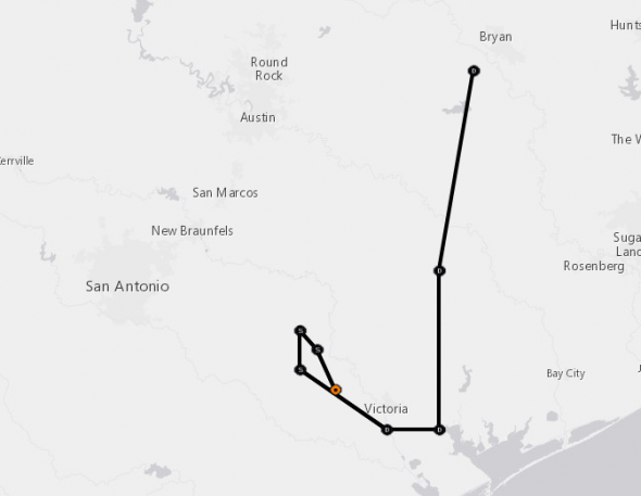
Harvey will spend the next 72 hours retracing its steps before heading north again as a tropical storm. Times as of 1000 CDT.
NOW 26/1500Z 28.9N 97.3W 65 KT 75 MPH…INLAND
12H 27/0000Z 29.1N 97.4W 45 KT 50 MPH…INLAND
24H 27/1200Z 29.2N 97.5W 40 KT 45 MPH…INLAND
36H 28/0000Z 29.0N 97.5W 35 KT 40 MPH…INLAND
48H 28/1200Z 28.7N 97.0W 30 KT 35 MPH…INLAND
72H 29/1200Z 28.7N 96.7W 30 KT 35 MPH…INLAND
96H 30/1200Z 29.5N 96.7W 30 KT 35 MPH…INLAND
120H 31/1200Z 30.5N 96.5W 30 KT 35 MPH…INLAND
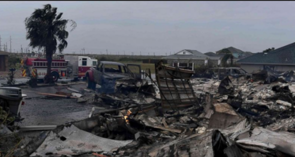
Damage Reports
Rockport, TX is reporting that multiple people are trapped in a collapsed building and several other structures were completely destroyed.
https://twitter.com/TheAaronColyer/status/901291935972810752
Latest storm / damage reports from Hurricane #Harvey: pic.twitter.com/X0LfPcu33O
— Scott Sistek (@ScottSeattleWx) August 26, 2017
Report in from Rockport, TX in #Harvey. Also NWS reports large portions of Rockport High School have collapsed pic.twitter.com/XnWX4ejytA
— Scott Sistek (@ScottSeattleWx) August 26, 2017
Tons of Rain and Power Outages
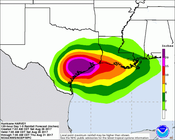
The rainfall potential of this storm is enormous as 30 inches of rain are expected along much of the Texas Gulf coast and areas just inland. Up to 56 inches of rain could fall in some areas. The rain and wind will continue to push trees into power lines and flooding will make it difficult for crews to make repairs.
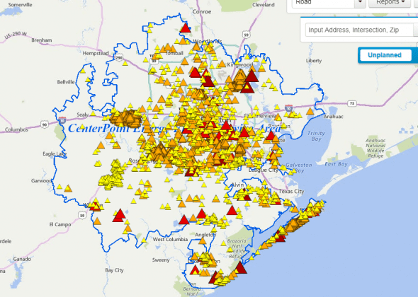
Almost 300,000 are without power due to the storm. More outages are expected over the next several days. Repairs in some areas could take days or weeks to complete.
The two largest energy providers in southeast Texas AEP and Centerpoint are reporting a combined total or about 240,000 customers without electricity. San Antonio’s CPS reports just over 6,000 without power and smaller power companies are reporting an addition 32,000 altogether.
Harvey Watches and Warnings
A Storm Surge Warning is in effect for…
* Baffin Bay to High Island Texas
A Hurricane Warning is in effect for…
* Baffin Bay to Port O’Connor Texas
A Tropical Storm Warning is in effect for…
* North of Port O’Connor to High Island Texas
What do the watches and warnings mean?
A Storm Surge Watch means there is a possibility of life-threatening inundation, from rising water moving inland from the coastline, in the indicated locations during the next 48 hours.
A Storm Surge Warning means there is a danger of life-threatening inundation, from rising water moving inland from the coastline, during the next 36 hours in the indicated locations. This is a life-threatening situation. Persons
located within these areas should take all necessary actions to protect life and property from rising water and the potential for other dangerous conditions. Promptly follow evacuation and other instructions from local officials.
A Hurricane Watch means that hurricane conditions are possible within the watch area. A watch is typically issued 48 hours before the anticipated first occurrence of tropical-storm-force winds, conditions that make outside preparations difficult or dangerous.
A Hurricane Warning means that hurricane conditions are expected somewhere within the warning area. A warning is typically issued 36 hours before the anticipated first occurrence of tropical-storm-force winds, conditions that make outside preparations difficult or dangerous. Preparations to protect life and property should be rushed to completion.
A Tropical Storm Watch means that tropical storm conditions are possible within the watch area, generally within 48 hours.
A Tropical Storm Warning means that tropical storm conditions are expected somewhere within the warning area within 36 hours.