Latest on Irma
Irma, already a strong category five hurricane, is moving through the British Virgin Islands now, will skirt Puerto Rico late Wednesday, hit the Bahamas Thursday/Friday, and continue on a track near Florida this weekend as a major Hurricane.
This post is OUTDATED – follow all of our latest Irma coverage HERE.
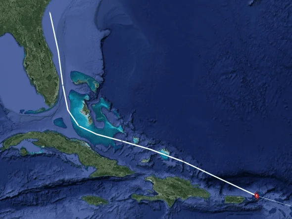
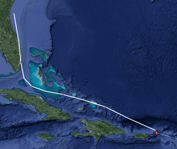
Hurricane Irma’s Current Position and Track
That national weather service has moved their forecast eastward to show landfall in southeastern Florida somewhere from Miami to West Palm Beach area and the latest computer models show a similar track.
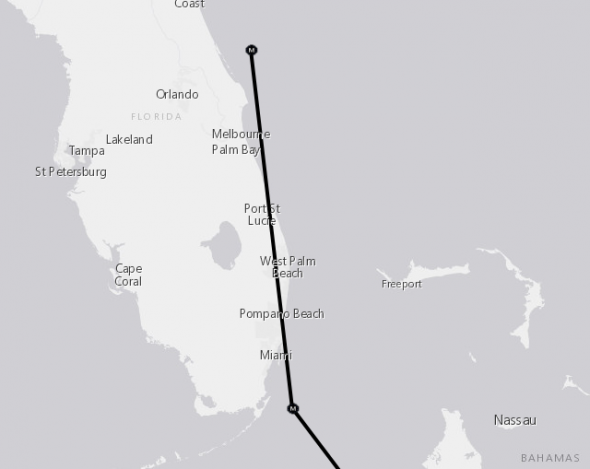
NWS has been steadily moving their track east matching the models and the plot may continue to move that way after the next model run at 2p EDT.
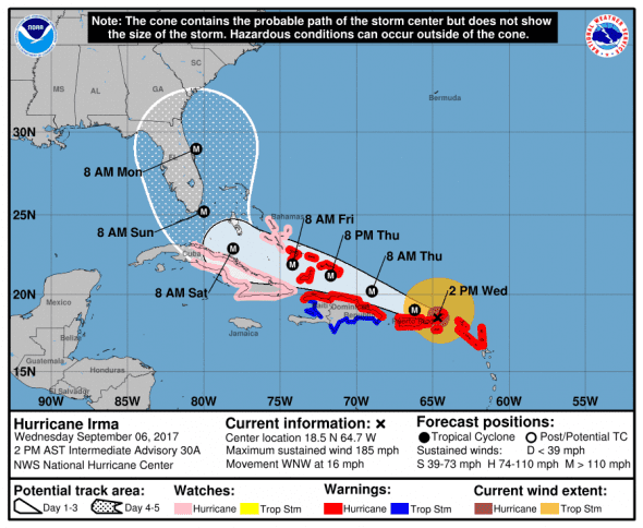
1400 AST/EDT (1800 UTC) Update from National Weather Service
- Location: 18.5 N, 64.7 W – British Virgin Islands
- Strength: 185 mph max sustained winds (Very Strong Category 5)
- Movement: WNW (285 deg.) at 16 mph
- Pressure: 920 mb and rising which may indicate weakening
*next update at 8 pm EDT – check our Irma update page for new information
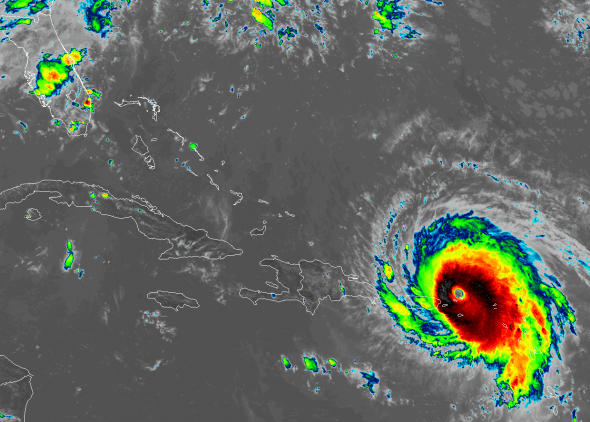
The latest satellite imagery shows the clearly defined eyewall and strong outflow expected from a storm of this intensity.
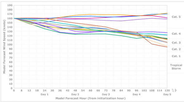
Irma is a very strong category five storm but is expected to weaken to a category four hurricane with 145 mph winds over the next 4 days as it skirts Puerto Rico and hits the Bahamas before approaching Florida.
Catastrophic damage will occur: A high percentage of framed homes will be destroyed, with total roof failure and wall collapse. Fallen trees and power poles will isolate residential areas. Power outages will last for weeks to possibly months. Most of the area will be uninhabitable for weeks or months.
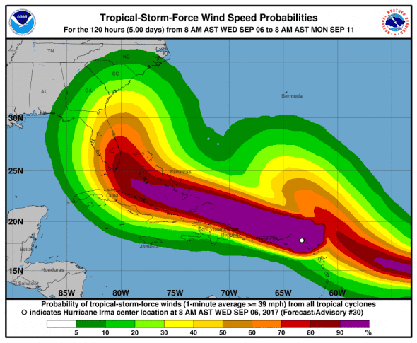
Hurricane-force winds extend outward up to 50 miles (85 km) from the center and tropical-storm-force winds extend outward up to 185 miles (295 km).
Computer Models for Hurricane Irma
Computer models are widely varied as to Irma’s track through the Florida straights and near Florida. The timing of the storm’s northward turn is widely varied which could lead to a Florida landfall or send Irma to Georgia or South Carolina for landfall.
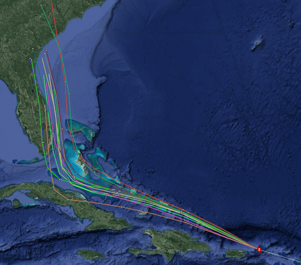
Early cycle model consensus has drifted a bit westward since the last run.
Late cycle model consensus puts the track making landfall in Miami and continuing up the coast to Port St. Lucie mirroring the track forecast by NWS.
The computer models are forming consensus around two different possibilities for Irma’s continued strength. One set shows the storm holding onto 185+ mph winds while the other group expects the storm to continually weaken over the next few days to between 120 to 145 mph.
U.S. Impacts
Florida
The National Weather Service forecasts a direct hit to southeast Florida but model consensus has moved east and indicates much less of a threat. As the storm could go anywhere in the forecast cone, Florida is still in danger of a direct impact. Florida’s Governor Rick Scott has declared a state of emergency to help the state prepare for what could be a major hurricane when it reaches the sunshine state.
Today, Governor Rick Scott issued Executive Order 17-235 declaring a state of emergency in all 67 counties within the State of Florida in response to Hurricane Irma – a major Category 4 storm approaching Florida. By declaring a state of emergency in all 67 Florida counties, Governor Scott is ensuring that local governments have ample time, resources and flexibility to get prepared for this dangerous storm and are not hindered, delayed or prevented from taking all necessary actions to keep communities safe.
Floridians should start preparing now to either shelter-in-place or evacuate. If Irma tracks towards Florida, additional evacuations will likely be posted. Don’t wait until the last minute and please listen to local authorities for instructions.
Georgia
No evacuation orders are in place. Atlanta area hotels have begun filling up as those in low-lying areas seek shelter.
South Carolina
South Carolina has declared a state of emergency, no evacuation orders are in place.
Governor Henry McMaster said that residents should start preparations for Irma as if she were coming tomorrow.
“Now is the time to prepare,” McMaster warned during a news conference at the S.C. Emergency Management Division headquarters on Wednesday. “When it’s too late, it’s too late and that’s when we have a lot sadness.”
Watches and Warnings
Areas under Hurricane Warning
* Saint Martin and Saint Barthelemy
* British Virgin Islands
* U.S. Virgin Islands
* Puerto Rico, Vieques, and Culebra
* Dominican Republic from Cabo Engano to the northern border with
Haiti
* Haiti from the northern border with the Dominican Republic to Le
Mole St. Nicholas
* Southeastern Bahamas and the Turks and Caicos Islands
Areas under Hurricane Watch
* Cuba from Matanzas province eastward to Guantanamo province
* Central Bahamas
Areas under Tropical Storm Warning
* Dominican Republic from south of Cabo Engano westward to the
southern border with Haiti
* Haiti from south of Le Mole St. Nicholas to Port-Au-Prince
Areas under Tropical Storm Watch
* None
What to Expect from Hurricane Irma
STORM SURGE: The combination of a life-threatening storm surge and large breaking waves will raise water levels ABOVE NORMAL TIDE LEVELS by the following amounts within the hurricane warning area near and to the north of the center of Irma. Near the coast, the surge will be accompanied by large and destructive waves.
- Northern Leeward Islands…7 to 11 ft
- Turks and Caicos Islands…15 to 20 ft
- Southeastern Bahamas…15 to 20 ft
- Northern coast of the Dominican Republic…3 to 5 ft
- Northern coast of Haiti and the Gulf of Gonave…1 to 3 ft
The combination of a life-threatening storm surge and the tide will cause normally dry areas near the coast to be flooded by rising waters moving inland from the shoreline. The water is expected to reach the following HEIGHTS ABOVE GROUND if the peak surge occurs at the time of high tide…
- British and U.S. Virgin Islands except St. Croix…7 to 11 ft
- Northern coast of Puerto Rico…4 to 6 ft
- Southern coast of Puerto Rico and St. Croix…2 to 4 ft
The deepest water will occur along the immediate coast in areas of onshore winds, where the surge will be accompanied by large and destructive waves. Surge-related flooding depends on the relative timing of the surge and the tidal cycle, and can vary greatly over short distances. For information specific to your area, please see products issued by your local National Weather Service forecast office.
WIND: Hurricane conditions will continue today within the hurricane warning area in the Leeward Islands. Hurricane conditions are occurring over the British and U.S. Virgin Islands and will spread westward over portions of Puerto Rico later today. Hurricane conditions are expected to begin within the hurricane warning area in the Dominican Republic and and Haiti on Thursday, with tropical storm conditions beginning tonight. Hurricane conditions are expected in the warning area in the southeastern Bahamas and the Turks and Caicos Islands beginning Thursday night.
Hurricane and tropical storm conditions are possible within the watch area in the central Bahamas and Cuba by Friday.
RAINFALL: Irma is expected to produce the following rain accumulations through Saturday:
- Northern Leeward Islands…8 to 12 inches, isolated 20 inches
- Northeast Puerto Rico and the British and U.S. Virgin Islands…4 to 10 inches, isolated 15 inches
- Southwest Puerto Rico, the southern Leeward Islands, and Saint Croix…2 to 4 inches
- Southeast Bahamas and Turks and Caicos…8 to 12 inches, isolated 20 inches
- Northern Dominican Republic, northern Haiti, eastern and central Cuba…4 to 10 inches, isolated 15 inches
Southwest Haiti…1 to 4 inches
In all areas, this rainfall may cause life-threatening flash floods and mudslides.
SURF: Swells generated by Irma will affect the northern Leeward Islands, Puerto Rico, the Virgin Islands, the southeastern Bahamas, the Turks and Caicos Islands, the northern coast of the Dominican Republic, and portions of the southeast coast of the United States during the next several days. These swells are likely to cause life-threatening surf and rip current conditions.
When to Expect Hurricane Irma and Where
INIT 06/1500Z 18.2N 64.0W 160 KT 185 MPH
12H 07/0000Z 19.0N 66.2W 155 KT 180 MPH – 37 miles north of Puerto Rico
24H 07/1200Z 20.2N 69.0W 150 KT 175 MPH – 75 northwest of the Dominican Republic
36H 08/0000Z 21.2N 71.7W 145 KT 165 MPH – 35 miles south of Turks and Caicos
48H 08/1200Z 21.9N 74.2W 140 KT 160 MPH – 104 miles northeast of Cuba
72H 09/1200Z 22.9N 78.1W 135 KT 155 MPH – 33 miles northeast of Cuba
96H 10/1200Z 25.2N 80.0W 125 KT 145 MPH – 19 miles east-southeast of North Key Largo, Florida
120H 11/1200Z 29.0N 80.5W 110 KT 125 MPH – 35 miles southeast of Daytona Beach, Florida