Irma, already a strong category five hurricane, is likely to strike several eastern Caribbean islands in the next 8 to 24 hours and continue on a track very likely to heavily impact Florida this weekend as a major Hurricane.
Follow our latest Irma coverage HERE.
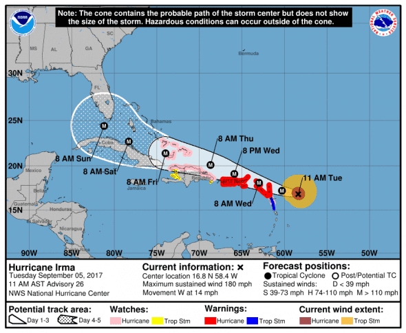
1100 AST (1500 UTC) Update from National Weather Service
- Location: 16.8 N, 58.4 W
- Strength: 180mph max sustained winds (Strong Category 5)
- Movement: W (270 deg.) at 14 mph
- Pressure: 931 mb and rising which may indicate weakening or an eye wall replacement cycle
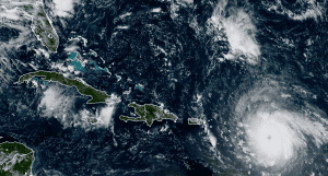
Latest satellite imagery shows the eye clouding over in what may be another eye wall replacement cycle which will slow strengthening until it completes.
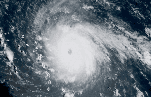
Irma is a category five storm and is expected to maintain 180 mph winds over the next 12 hours before it begins a weakening trend as it heads towards the coast of Florida.
Catastrophic damage will occur: A high percentage of framed homes will be destroyed, with total roof failure and wall collapse. Fallen trees and power poles will isolate residential areas. Power outages will last for weeks to possibly months. Most of the area will be uninhabitable for weeks or months.
Hurricane-force winds extend outward up to 45 miles (75 km) from the center and tropical-storm-force winds extend outward up to 140 miles (220 km).
Computer Models for Hurricane Irma
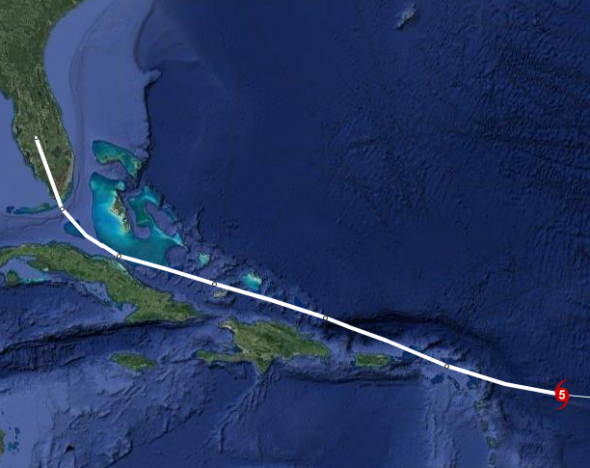
5-day weather models put Irma just south of or over southern Florida on Sunday. The models separate slightly after that, but consensus shows an increasing chance that Irma will directly impact Florida. The chance that Florida takes a direct south-to-north hit by a major hurricane is increasing by the hour. Models expect Irma to be a category 3 major hurricane as it nears the Florida coast.
Note: models become drastically more error-prone beyond a 5-day range.
U.S. Impacts
Model consensus continues to point to an increasingly likely impact to Florida and the Florida Keys from Hurricane Irma. Florida’s Governor Rick Scott has declared a state of emergency to help the state prepare for what could be a major hurricane when it reaches the sunshine state.
Today, Governor Rick Scott issued Executive Order 17-235 declaring a state of emergency in all 67 counties within the State of Florida in response to Hurricane Irma – a major Category 4 storm approaching Florida. By declaring a state of emergency in all 67 Florida counties, Governor Scott is ensuring that local governments have ample time, resources and flexibility to get prepared for this dangerous storm and are not hindered, delayed or prevented from taking all necessary actions to keep communities safe.
If the storm takes the current model’s predicted course, straight up the middle of the Florida peninsula, damage could be catastrophic for the state. The storm could devastate communities from the Keys to the panhandle in a matter of just over 24 hours. Floridians should start preparing now to either shelter in-place or evacuate. Don’t wait until the last minute and please listen to local authorities for instructions.
Watches and Warnings
Areas under Hurricane Warning
* Antigua, Barbuda, Anguilla, Montserrat, St. Kitts, and Nevis
* Saba, St. Eustatius, and Sint Maarten
* Saint Martin and Saint Barthelemy
* British Virgin Islands
* U.S. Virgin Islands
* Puerto Rico, Vieques, and Culebra
Areas under Hurricane Watch
* Guadeloupe
* Dominican Republic from Cabo Engano to the northern border with
Haiti
* Haiti from the northern border with the Dominican Republic to Le
Mole St. Nicholas
* Turks and Caicos Islands
* Southeastern Bahamas
Areas under Tropical Storm Warning
* Guadeloupe
* Dominica
Areas under Tropical Storm Watch
* Dominican Republic from south of Cabo Engao to Isla Saona
* Haiti from south of Le Mole St. Nicholas to Port-Au-Prince
What to Expect from Hurricane Irma
STORM SURGE: The combination of a life-threatening storm surge and large breaking waves will raise water levels by as much as 7 to 11 feet above normal tide levels along the coasts of the extreme northern Leeward Islands within the hurricane warning area near and to the north of the center of Irma. Near the coast, the surge will be accompanied by large and destructive waves.
The combination of a life-threatening storm surge and the tide will cause normally dry areas near the coast to be flooded by rising waters moving inland from the shoreline. The water is expected to reach the following heights above ground if the peak surge occurs at the time of high tide…
- British and U.S. Virgin Islands except St. Croix…7 to 11 ft
- Northern coast of Puerto Rico…3 to 5 ft
- Southern coast of Puerto Rico and St. Croix…1 to 2 ft
The deepest water will occur along the immediate coast in areas of onshore winds, where the surge will be accompanied by large and destructive waves. Surge-related flooding depends on the relative timing of the surge and the tidal cycle, and can vary greatly over short distances. For information specific to your area, please see products issued by your local National Weather Service forecast office.
WIND: Hurricane conditions are expected within the hurricane warning area in the Leeward Islands by tonight, with tropical storm conditions beginning later today. Tropical storm conditions are expected within the tropical storm warning area where hurricane conditions are also possible. Hurricane conditions are expected to begin within the hurricane warning area in the British and U.S. Virgin Islands and Puerto Rico on Wednesday, with tropical storm
conditions beginning tonight.
Hurricane and tropical storm conditions are possible within the watch area in the Dominican Republic, Haiti, the Turks and Caicos, and the southeastern Bahamas by early Thursday.
RAINFALL: Irma is expected to produce total rain accumulations of 8 to 12 inches with isolated maximum amounts of 18 inches across the northern Leeward Islands. Irma is expected to produce total rain accumulations of 4 to 10 inches with isolated maximum amounts of 15 inches across northeast Puerto Rico and the British and U.S. Virgin Islands, and amounts of 2 to 4 inches over southwest Puerto Rico, the southern Leeward Islands, and Saint Croix. This rainfall
may cause life-threatening flash floods and mudslides.
SURF: Swells generated by Irma will affect the northern Leeward Islands, Puerto Rico, and the U.S. and British Virgin Islands during the next several days. These swells are likely to cause life-threatening surf and rip current conditions.
When to Expect Hurricane Irma
NOW 05/1500Z 16.8N 58.4W 155 KT 180 MPH
12H 06/0000Z 17.2N 60.3W 155 KT 180 MPH
24H 06/1200Z 18.1N 63.0W 150 KT 175 MPH
36H 07/0000Z 19.1N 65.9W 145 KT 165 MPH
48H 07/1200Z 20.1N 68.7W 140 KT 160 MPH
72H 08/1200Z 21.4N 74.0W 135 KT 155 MPH
96H 09/1200Z 22.7N 78.3W 130 KT 150 MPH
120H 10/1200Z 24.4N 81.2W 125 KT 145 MPH