Tropical storm Harvey now has winds of 40 mph and the storm is expected to hold that strength for a few more days and its track will add more rain to the catastrophic flooding and tornado activity in the Houston area for several more days. 70,000 people are without power in the Houston/Galveston region. The tornado threat from Harvey cannot be understated as several tornadoes have spawned on the northeast side of the storm.
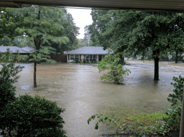
Video and pictures of flooding and rescue efforts around Houston are HERE.
Get the latest on Harvey on our Storm Page

National Weather Service update 8-27-17 – 22:00 CDT: (for our complete Harvey coverage, visit our Harvey page)
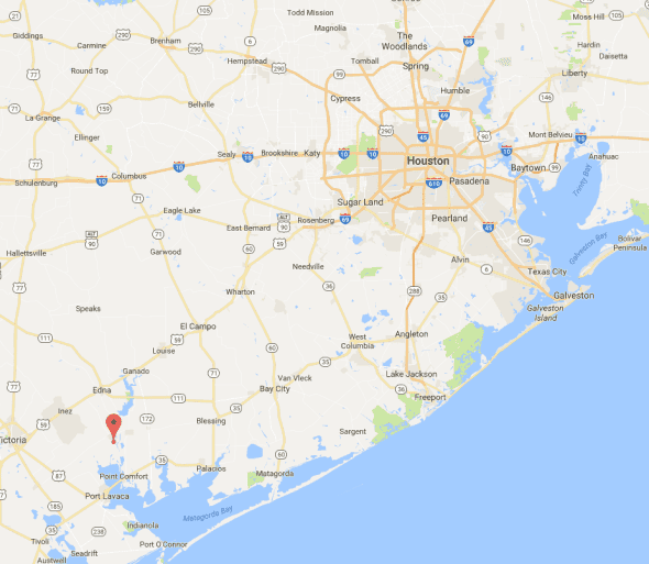
Harvey was last reported at 28.8N, 96.6W and is moving east-southeast at 3 mph with maximum sustained winds of 40 mph. The estimated minimum central pressure based on data from NOAA and Air Force Hurricane Hunter aircraft is 1000 mb (29.53 inches) and steady indicating neither strengthening nor weakening of the storm.
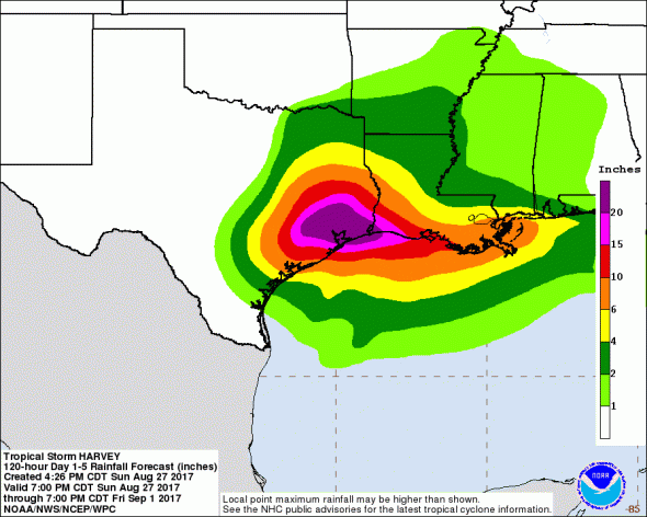
“500-year flood”
Flooding in Houston will be catastrophic. 20 inches of rain has already inundated the fourth most populous city in the nation and another 20-30 inches are forecast for the area. For videos and images of the flooding in Houston, go HERE.
“We’re told people were breaking glass to get inside [local businesses] because the water was coming down so fast,” .@DeMarcoReports says pic.twitter.com/KhXDAWQ2Fr
— CBS News (@CBSNews) August 27, 2017
%CODE2%
Daylight reveals the extent of flooding in Houston #hurricane #harvey #Houston buffalobayoupark #flood #flooding #… https://t.co/YCyGkAJg6M pic.twitter.com/wAYU7zZz7G
— DoubleHorn Photo (@DoubleHornPhoto) August 27, 2017
Casualties
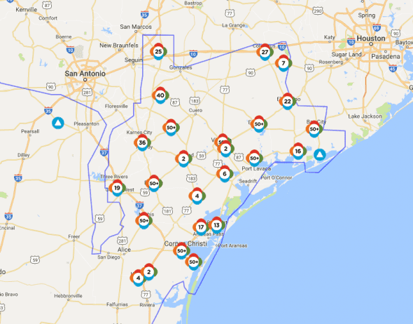
There are 2 people confirmed dead and another 14 injured after Harvey’s initial push through southeast Texas. As flooding takes hold, whichever number is correct will increase drastically. More people are killed after the initial strike than during it in almost every major hurricane. There are reports of as many as 20 more deaths, but as the location of the reports is unreachable by officials, no confirmation can be made.
Where will Harvey Go Next
Harvey will continue heading offshore for another 36 hours or so before turning to the northeast and passing close to Houston. The north eastern quadrant of the storm is the most-violent and will pass over the Baytown area early Wednesday.
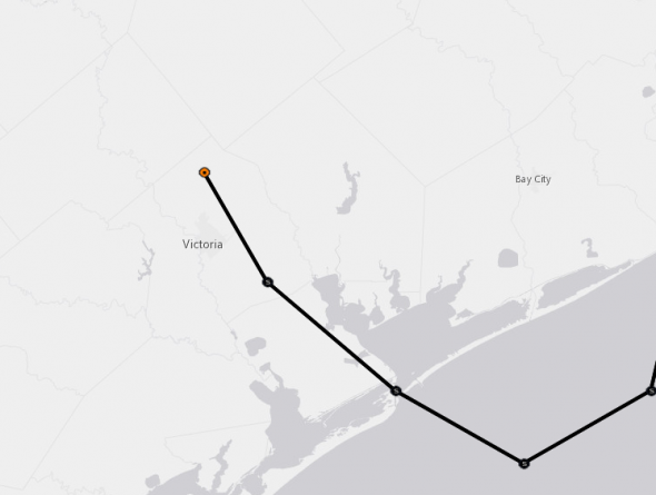
Harvey will spend the next 72 hours heading for Matagorda Bay before a 36-hour offshore run that will allow the storm to maintain 35+ mph winds and pick up more moisture. In 72 hours, Harvey will take a northward turn again as a tropical depression. Houston’s rain troubles may be joined by a wind event within the next 3-4 days.
Forecast positions and wind speeds. Times as of 1600 CDT.
NOW 28/0300Z 28.8N 96.6W 35 KT 40 MPH…INLAND
12H 28/1200Z 28.6N 96.4W 35 KT 40 MPH…NEAR THE COAST
24H 29/0000Z 28.3N 96.0W 40 KT 45 MPH…OVER WATER
36H 29/1200Z 28.4N 95.7W 40 KT 45 MPH…OVER WATER
48H 30/0000Z 28.8N 95.3W 40 KT 45 MPH…OVER WATER
72H 31/0000Z 30.5N 94.8W 35 KT 40 MPH…INLAND
96H 01/0000Z 32.3N 93.9W 30 KT 35 MPH…INLAND
120H 02/0000Z 34.0N 92.5W 25 KT 30 MPH…INLAND
Tons of Rain and Power Outages
The rainfall potential of this storm is enormous as 30 inches of rain are expected along much of the Texas Gulf coast and areas just inland. Up to 56 inches of rain could fall in some areas. The rain and wind will continue to push trees into power lines and flooding will make it difficult for crews to make repairs.
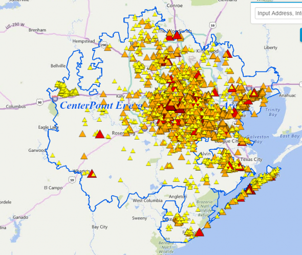
Almost 230,000 are without power due to the storm. More outages are expected over the next several days. Repairs in some areas could take days or weeks to complete.
The two largest energy providers in southeast Texas, AEP and Centerpoint, are reporting a combined total of about 225,000 customers without electricity. The Houston Metroplex was experiencing 75,000 outages as of 2200 CDT Sunday.
Harvey Watches and Warnings
A Tropical Storm Warning is in effect for…
* Port O’Connor to Sargent Texas
What do the watches and warnings mean?
A Storm Surge Watch means there is a possibility of life-threatening inundation, from rising water moving inland from the coastline, in the indicated locations during the next 48 hours.
A Storm Surge Warning means there is a danger of life-threatening inundation, from rising water moving inland from the coastline, during the next 36 hours in the indicated locations. This is a life-threatening situation. Persons
located within these areas should take all necessary actions to protect life and property from rising water and the potential for other dangerous conditions. Promptly follow evacuation and other instructions from local officials.
A Hurricane Watch means that hurricane conditions are possible within the watch area. A watch is typically issued 48 hours before the anticipated first occurrence of tropical-storm-force winds, conditions that make outside preparations difficult or dangerous.
A Hurricane Warning means that hurricane conditions are expected somewhere within the warning area. A warning is typically issued 36 hours before the anticipated first occurrence of tropical-storm-force winds, conditions that make outside preparations difficult or dangerous. Preparations to protect life and property should be rushed to completion.
A Tropical Storm Watch means that tropical storm conditions are possible within the watch area, generally within 48 hours.
A Tropical Storm Warning means that tropical storm conditions are expected somewhere within the warning area within 36 hours.