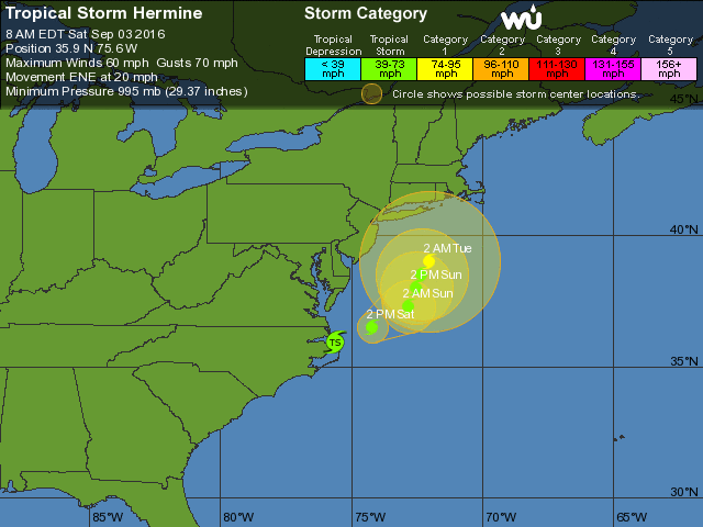
Check back regularly for Hermine updates.
As of: 9/03/16 08:00 ET
Hermine Current Stats:
- Location: 35.9N 75.6W
- Max sustained winds: 60mph and strengthening
- Direction and speed: ENE 20mph
- Pressure: 995MB and decreasing
Current Track:
Hermine is expected to regain hurricane strength Saturday as it tracks towards the northeast atlantic U.S. coast.
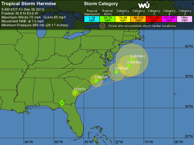
As of: 9/02/16 05:00 ET
Hermine Current Stats:
- Location: 30.8N 83.6W
- Max sustained winds: 70mph and weakening
- Direction and speed: NNE 14mph
- Pressure: 988MB and increasing
Current Track:
Hermine is has dropped back down to a tropical storm (<7580mph max sustained winds) . Hermine is expected to remain a tropical or extra-tropical system as it plows through eastern Georgia, South Carolina and North Carolina. Hermine’s track through the Carolinas has moved significantly to the east from yesterday’s predictions.
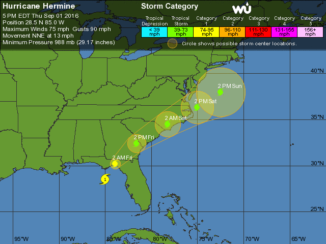
As of: 9/01/16 20:00 ET
Hermine Current Stats:
- Location: 29.1N 84.8W
- Max sustained winds: 80mph and increasing
- Direction and speed: NNE 14mph
- Pressure: 983MB and decreasing
Current Track:
Hermine is a category one Hurricane (80mph max sustained winds) . Hermine is expected to hit the Florida panhandle around 2am Friday morning as a category one storm before returning to tropical or extra-tropical classification as it plows through eastern Georgia, South Carolina and North Carolina. Hermine’s track through the Carolinas has moved significantly to the east from yesterday’s predictions.
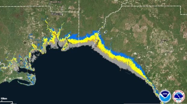
Hurricane Hermine Storm Surge Map
Hermine is now predicted to produce a much higher storm surge across a much wider area than previously forecast. Surge levels could reach 12 feet above ground in Coastal Taylor county and southeastern Jefferson county along the coast.

As of: 9/01/16 19:00 ET
Hermine Current Stats:
- Location: 28.5N 85.0W
- Max sustained winds: 75mph and increasing
- Direction and speed: NNE 14mph
- Pressure: 988MB and decreasing
Current Track:
Hermine is now a category one Hurricane (75mph max sustained winds) as of the 5pm update. Hermine is expected to hit the Florida panhandle around 2am Friday morning as a category one storm before returning to tropical or extra-tropical classification as it plows through eastern Georgia, South Carolina and North Carolina.
Hurricane Hermine Storm Surge Map
Hermine is now predicted to produce a much higher storm surge across a much wider area than previously forecast. Surge levels could reach 12 feet above ground in Coastal Taylor county and southeastern Jefferson county along the coast.
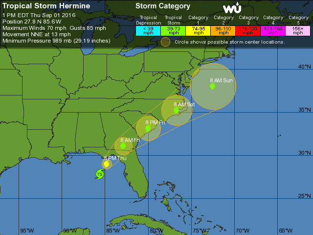
As of: 9/01/16 13:00 ET
Hermine Current Stats:
- Location: 27.8N 85.6W
- Max sustained winds: 71mph and increasing
- Direction and speed: NNE 14mph
- Pressure: 989MB and decreasing
Current Track:
Hermine is forecast to increase to Hurricane strength (75mph max sustained winds) around 5pm Thursday and hit the Florida panhandle around 2am Friday morning. The storm is now expected to then return to tropical or extra-tropical classification as it plows through eastern Georgia, South Carolina and North Carolina.
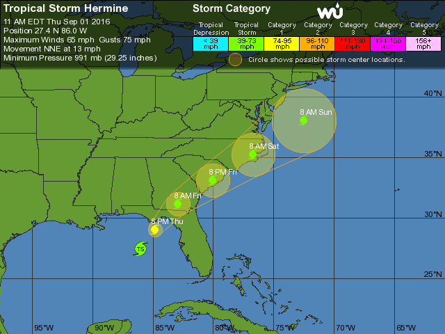
As of: 9/01/16 11:00 ET
Hermine Current Stats:
- Location: 27.4N 86.0W
- Max sustained winds: 65mph and increasing
- Direction and speed: NNE 14mph
- Pressure: 991MB and decreasing
Current Track:
Hermine is forecast to hit the Florida panhandle around 2am Friday morning. The storm is now expected to increase to hurricane strength just before it makes landfall then return to tropical or extra-tropical classification as it plows through eastern Georgia, South Carolina and North Carolina.
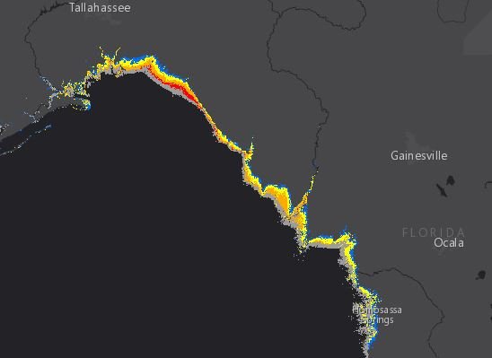
Hermine Storm Surge Potential
The storm is expected to produce storm surge greater than 6ft in coastal areas of Wakulla, Jefferson, Taylor and Dixie counties. (orange = 6+ feet, yellow = 3+ feet, blue is 1+ feet)

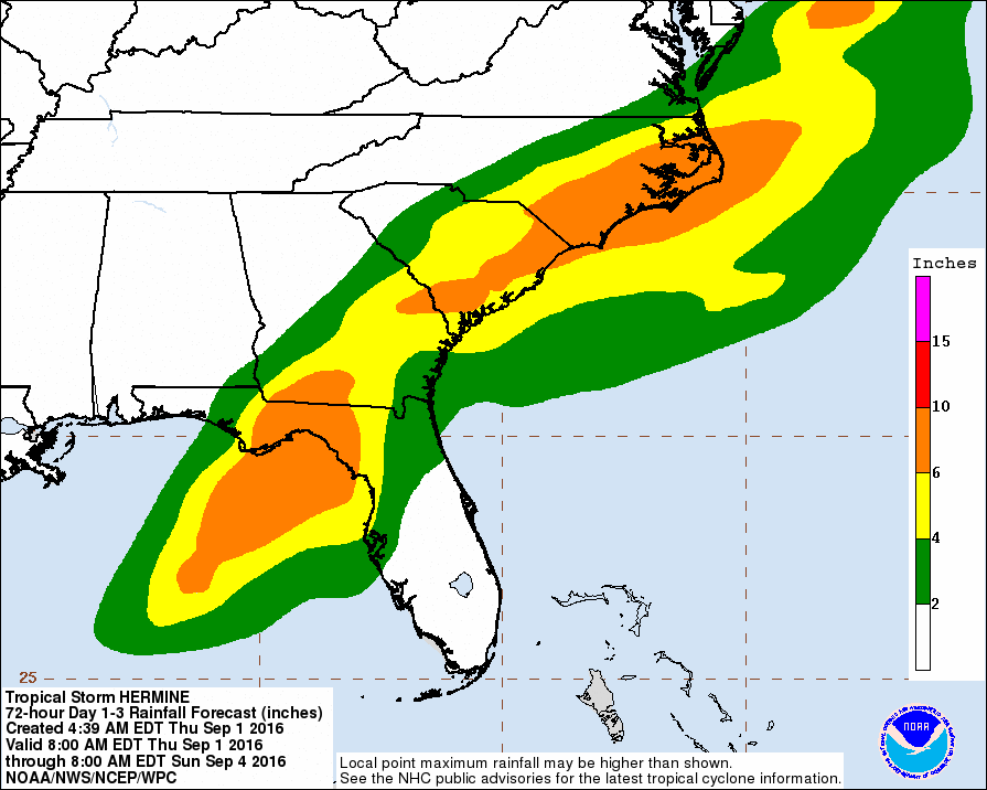
Rainfall prediction along Hermine’s path
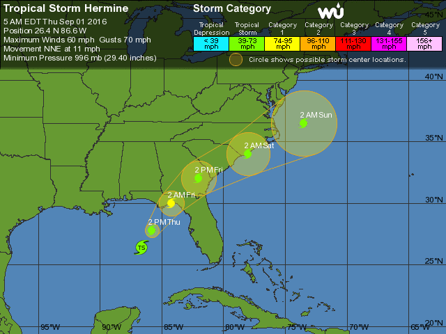
As of: 9/01/16 05:00 ET
Hermine is strengthening this morning while gaining speed. The storm’s forecast path has moved slightly east from the previously forecast track.
Hermine Current Stats:
- Location: 26.4N 86.6W
- Max sustained winds: 60mph and increasing
- Direction and speed: NNE 12mph
- Pressure: 996MB and decreasing
Current Track:
Hermine is forecast to hit the Florida panhandle around 2am Friday morning. The storm is now expected to increase to hurricane strength just as it makes landfall then return to tropical or extra-tropical classification as it plows through the eastern Georgia, South Carolina and North Carolina.
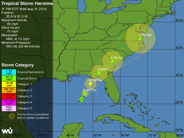
As of: 8/31/16 23:00 ET
Hermine is strengthening this evening while gaining speed along the previously forecast track.
Hermine Current Stats:
- Location: 25.8N 87.0W
- Max sustained winds: 60mph and increasing
- Direction and speed: NNE 10mph
- Pressure: 998MB and decreasing
Current Track:
Hermine is forecast to hit the Florida panhandle around 2am Friday morning. The storm is now expected to increase to hurricane strength as it makes landfall then return to tropical or extra-tropical classification as it plows through the middle of Georgia, South Carolina and North Carolina.
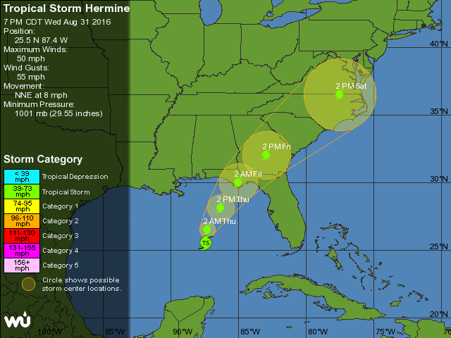
As of: 8/31/16 19:41 ET
This afternoon, Tropical Depression 9 grew into a tropical storm and was named Hermine.
Hermine Current Stats:
- Location: 25.5N 87.4W
- Max sustained winds: 50mph and increasing
- Direction and speed: NNE 8mph
- Pressure: 1001MB
Current Track:
Hermine is forecast to hit the Florida panhandle around 2am Friday morning. The storm is expected to maintain tropical strength as it plows through the middle of Georgia, South Carolina and North Carolina.
Storm Surge Prediction:
Storm surge is predicted to be 3-6 or more feet above ground with Jefferson, Taylor and Wakulla county coastal and inlet areas in Florida being the hardest hit. (blue is 1ft, yellow is 3+ ft and orange is 6+ feet.)