Latest on Irma
The latest update on Hurricane Irma shows the storm moving more west than had been forecast, but the storm is strengthening. As Irma approaches the Florida coast, almost 200,000 people are without power according to Florida Power & Light.
This post is OUTDATED – see our current Irma coverage HERE.
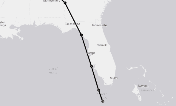
Hurricane Irma’s Current Position and Track
The national weather service is currently forecasting landfall in western Florida. Irma is forecast to first make land over Key West then head north-northwest. Irma is then forecast to make landfall on the southwestern coast of the mainland before tracking up the peninsula into Georgia, Alabama, and Tennessee.
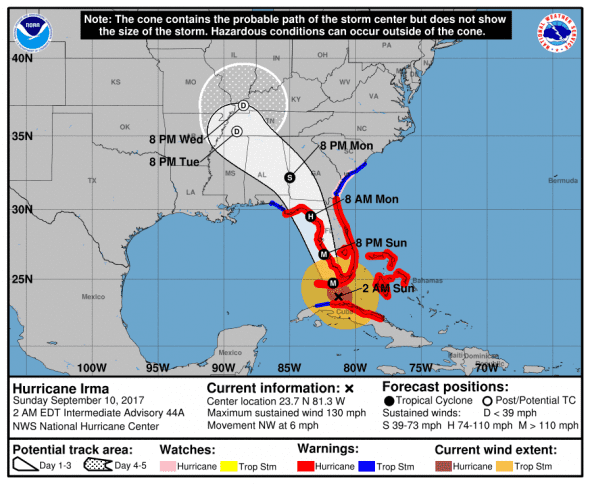
0200 AST/EDT (0600 UTC) Update from National Weather Service
- Location: 23.7N 81.2W 80 miles SE of Key West
- Strength: 130 mph max sustained winds (Category 4)
- Movement: NW (310 deg.) at 6 mph
- Pressure: 931 mb – same as last update
*next update at — am EDT – check our Irma update page for new information
The latest satellite imagery shows a much more structured eye that has grown large indicating strengthening as Irma heads for the Florida Keys.
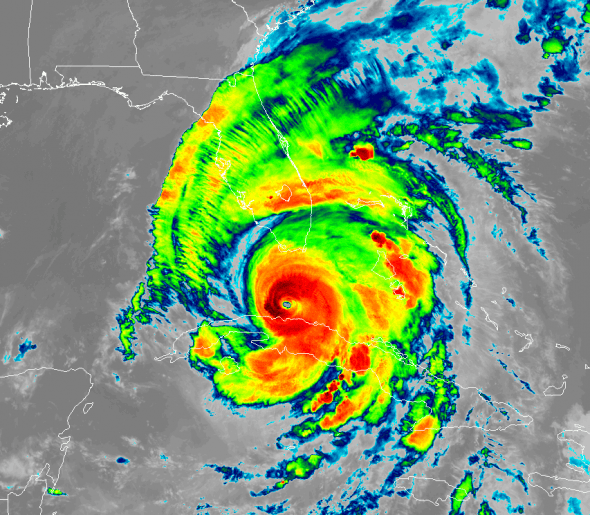
Irma is a strong category three storm that is expected to re-strengthen to a category four over the next 24-36 hours as it moves into the Gulf of Mexico before making landfall in Florida. We will have to watch to see if the storm continues to strengthen or weaken as it heads for Florida.
Catastrophic damage will occur: Well-built framed homes can sustain severe damage with loss of most of the roof structure and/or some exterior walls. Most trees will be snapped or uprooted and power poles downed. Fallen trees and power poles will isolate residential areas. Power outages will last weeks to possibly months. Most of the area will be uninhabitable for weeks or months.
Hurricane-force winds extend outward up to 70 miles (110 km) from the center, and tropical-storm-force winds extend outward up to 195 miles (315 km). Marathon International Airport recently reported a sustained wind of 48 mph (77 km/h) and a gust to 67 mph (108 km/h).

Computer Models for Hurricane Irma (8 pm run 9/9)
Computer models range from a southwestern Florida landfall to staying just off the coast until the panhandle.
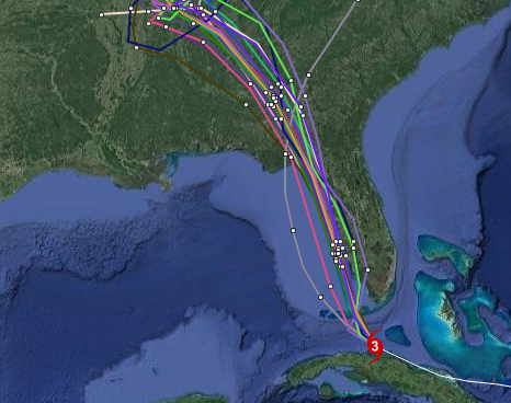
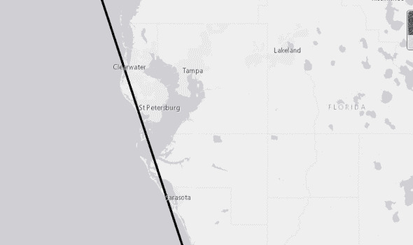
Early cycle model consensus forecasts that Irma will ride up the western side of Florida with landfall at Key West and again near St. Petersburg.
The late cycle model consensus forecasts a landfall in the Keys and again at Fort Myers Beach then riding up through the western side of the sunshine state.

The intensity models show some strengthening as Irma leaves Cuba and approaches Florida.
*next computer model update 8 am EDT
U.S. Impacts
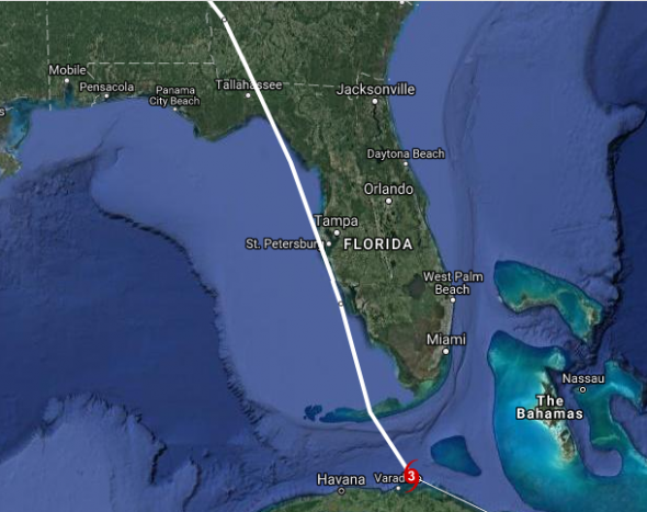
The NWS now predicts that the eye of Irma will almost completely miss Florida. As this will put the “dirty” northeast side of the storm over the coast for an extended period, this is not good news for the west coast of the sunshine state.
Florida
The National Weather Service forecasts a direct hit to the Florida Keys before it heads up the coast, brushes Sarasota, Florida and then slams into the Tampa Bay area.
Florida has declared a state of emergency and multiple areas have been ordered to evacuate immediately.
- EVACUATIONSThough the below evacuation orders are current and in effect, everyone should check with their local emergency management office or website for the most up to date information regarding evacuation as they are constantly being updated.
- DEM estimates that 6.3 million Floridians have been ordered to evacuate.
- While Col. Jason Kirk with the U.S. Army Corps of Engineers and the Corps. have assured the Governor that the structural integrity of the Dike will not be compromised, Governor Scott ordered mandatory evacuations in the cities surrounding the southern half of Lake Okeechobee from Lake Port to Canal Point in Hendry, Palm Beach and Glades counties. This decision was made due to Governor Scott’s sole focus on life safety as Hurricane Irma approaches Florida. The seven cities affected by these orders are as follows:
- South Bay
- Lake Harbor
- Pahokee
- Moore Haven
- Clewiston
- Belle Glade
- Canal Point
- Brevard – mandatory evacuations for Zone A, Merritt Island, barrier islands, and some low-lying mainland areas along Indian River Lagoon
- Broward – mandatory East of Federal Highway including barrier islands
- Charlotte – voluntary evacuations for Don Pedro Island, Knight Island (Palm Island), Little Gasparilla Island, Manosota Key, all mobile homes
- Citrus – mandatory evacuations for residents west of Hwy 19, 1 and ½ miles east of Hwy 19 excluding Sugarmill Woods. This also includes all of the city of Crystal River, all low lying areas throughout the entire county and anyone residing in mobile homes, manufactured homes and all unsafe structures throughout the entire county
- Collier – mandatory evacuations for Goodland, Everglades City, Chokoloskee, all mobile homes
- Desoto- voluntary evacuations for people in low-lying/flood prone areas, residents living in mobile homes and RV parks
- Flagler – mandatory evacuations for nursing homes, all varieties of assisted living facilities, and community residential group homes within coastal and Intracoastal areas and voluntary for zones A, B, C, F; mandatory for Zones A,B,C,F, and substandard housing beginning on Saturday
- Glades – mandatory evacuations for areas around Lake Okeechobee (Lakeport, Moorehaven, Washington Park, Benbow and Uncle Joe’s Motel and Campground). Also mandatory for residents in Zone A and anyone in an RV park, mobile home or building constructed before 1992.
- Hardee – voluntary evacuations for low-lying areas, mobile homes, and port structures
- Hendry – voluntary evacuations for low-lying areas, non-slab-built homes, mobile homes, trailers and RVs, mandatory for areas near Lake Okeechobee (Clewiston, Hookers Point, Harlem, Flaghole, Montura Ranch Estates, Mid-County MSBU which inlcudes Ladeca, Pioneer Plantation and Leon-Dennis Subdivision, Al Don Farming Road)
- Hernando – mandatory evacuations for Zones A and B and mobile homes
- Highlands – voluntary for low areas and mobile/manufactured homes
- Hillsborough – voluntary for special-needs residents in Evacuation Zone A.
- Indian River – voluntary evacuations for barrier islands, low-lying areas, mandatory for Saturday
- Lee – mandatory for Cape Coral west of Burnt Store Road and south of Cape Coral Parkway, east of Del Prado Boulevard to Viscaya Parkway, North Fort Myers south of Bay Shore Road from Moody Road to State Road 31 and areas south of North River Road from State Road 31 to Fichters Creek, areas of Iona south of Maple Drive, west of U.S. 41, San Carlos Park west of U.S. 41, Estero west of U.S. 41, north of the Estero River, Bonita Springs communities along Estero Bay and the Imperial River Basin, all of the barrier islands.
- Manatee – voluntary evacuations for Zone A and mobile homes.
- Martin – mandatory evacuations for barrier islands, manufactured homes, and low-lying areas beginning Saturday
- Miami-Dade – mandatory evacuations for all of Zone A, all of Zone B, and portions of Zone C. Miami Dade residents can find their zones by clicking HERE.
- Monroe – mandatory evacuations for visitors and residents. A dedicated transportation hotline is available specifically for individuals in the Keys at 305-517-2480
- Pasco – mandatory evacuations for residents living west of U.S. 19. Also mandatory for residents living north of Fox Hollow Drive west of Little Rd. and south of Fox Hollow Drive west of Regency Park Blvd./Rowan Rd./Seven Springs Blvd. Special needs residents, and those living in manufactured homes, mobile homes, RV’s, and anyone living in a low-lying area or an area prone to flooding are also under mandatory evacuation. Voluntary evacuations for residents living south of Fox Hollow Drive to the south county line between Regency Park Blvd./Rowan Rd./Seven Springs Blvd. and Little Rd.
- Palm Beach – mandatory evacuations for Zone A and B, voluntary for Zone C and Lake Zone E (Canal Point, Belle Glade, and Pahokee)
- Pinellas – mandatory evacuations all mobile home and Zone A
- Sarasota – voluntary evacuations in Zone A (Longboat, Lido, Siesta, Casey Key, Manasota Key, Venice Island), all mobile homes
- St. Lucie – mandatory north and south Hutchinson Island, low-lying areas, manufactured homes
- Additional evacuations are expected throughout the state. All Floridians should pay close attention to local alerts and follow the directions of local officials.
Floridians should start preparing now to either shelter-in-place or evacuate. As Irma tracks towards Florida, additional evacuations will likely be posted. Don’t wait until the last minute and please listen to local authorities for instructions.
Georgia
Georgia has declared a state of emergency. Gov. Nathan Deal issued a mandatory evacuation order Thursday for all areas east of I-95 and other parts of the state’s coast as Hurricane Irma barrels toward Florida and Georgia with potentially catastrophic force.
“I encourage all Georgians in our coastal areas that could be impacted by this storm to evacuate the area as soon as possible,” Deal said. “Beginning Saturday, a mandatory evacuation order will take effect for Chatham County, all areas east of I-95 and some areas west of I-95 that could be impacted by this catastrophic hurricane and storm surge. GEMA/HS continues leading our preparedness efforts as we coordinate with federal, state and local officials to safely evacuate the coastal areas, provide public shelter and minimize the disruption of traffic. Finally, I ask all Georgians to join me in praying for the safety of our people and all those in Hurricane Irma’s path.”
South Carolina
South Carolina has declared a state of emergency, coastal areas and barrier islands are under a mandatory evacuation order.
“Now is the time to prepare,” Gov. McMaster warned during a news conference at the S.C. Emergency Management Division headquarters on Wednesday. “When it’s too late, it’s too late and that’s when we have a lot sadness.”
North Carolina
Gov. Roy Cooper has declared a state of emergency for North Carolina. No evacuations have been ordered.
Watches and Warnings
Areas under storm surge warning
* South Santee River southward around the Florida peninsula to the
Suwanee River
* Florida Keys
* Tampa Bay
Areas under storm surge watch
* North of the Suwanee River to Ochlockonee River
Areas under Hurricane Warning
* Fernandina Beach southward around the Florida peninsula to Indian
Pass
* Florida Keys
* Lake Okeechobee
* Florida Bay
* Cuban provinces of Camaguey, Ciego de Avila, Sancti Spiritus,
Villa Clara, Matanzas, and Havana
* Andros Island, Bimini and Grand Bahama
Areas under Hurricane Watch
* North of Fernandina Beach to Edisto Beach
* West of the Aucilla River to Indian Pass
Areas under Tropical Storm Warning
* West of Indian Pass to the Okaloosa/Walton County Line
* North of Fernandina Beach to South Santee River
Areas under Tropical Storm Watch
* None
What to Expect from Hurricane Irma
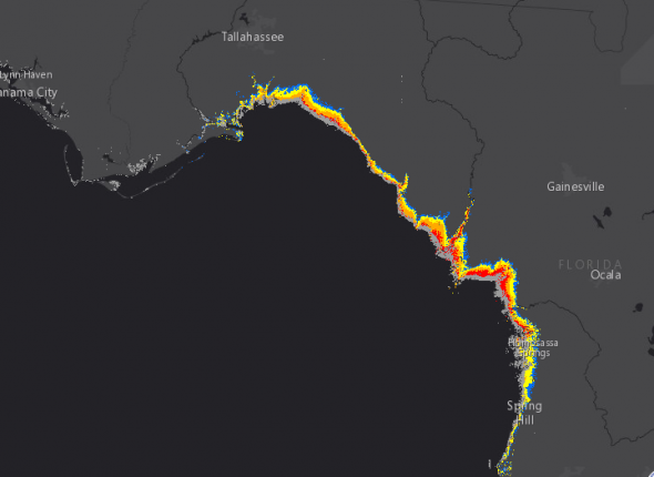
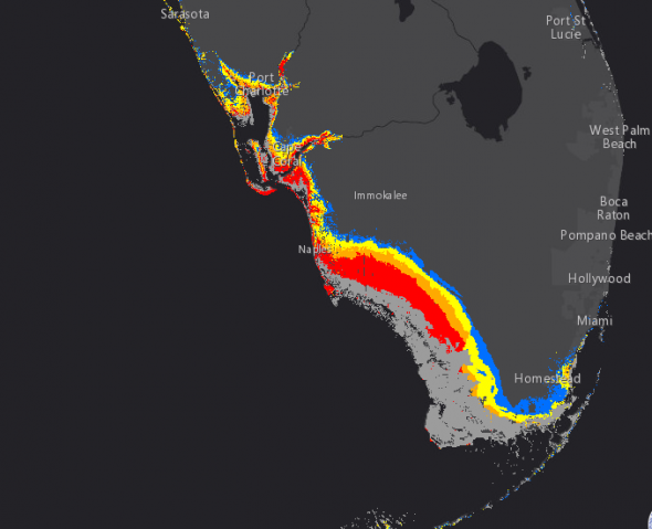
STORM SURGE: The combination of a dangerous storm surge and the tide will cause normally dry areas near the coast to be flooded by rising waters moving inland from the shoreline. The water is expected to reach the following HEIGHTS ABOVE GROUND if the peak surge occurs at the time of high tide…
- Cape Sable to Captiva…10 to 15 ft
- Captiva to Ana Maria Island…6 to 10 ft
- Card Sound Bridge through Cape Sable, including the Florida Keys…5 to 10 ft
- Ana Maria Island to Clearwater Beach, including Tampa Bay…5 to 8ft
- North Miami Beach to Card Sound Bridge, including Biscayne Bay…4to 6 ft
- Isle of Palms, South Carolina to Fernandina Beach…4 to 6 ft
- Clearwater Beach to Ochlockonee River…4 to 6 ft
- Fernandina Beach to North Miami Beach…2 to 4 ft

The deepest water will occur along the immediate coast in areas of onshore winds, where the surge will be accompanied by large and destructive waves. Surge-related flooding depends on the relative timing of the surge and the tidal cycle, and can vary greatly over short distances. For information specific to your area, please see products issued by your local National Weather Service forecast office.
The combination of a life-threatening storm surge and large breaking waves will raise water levels ABOVE NORMAL TIDE LEVELS by the following amounts within the hurricane warning area near and to the north of the center of Irma. Near the coast, the surge will be accompanied by large and destructive waves.
- Northwestern Bahamas…3 to 6 ft
- Northern coast of Cuba in the warning area…5 to 10 ft
WIND: Hurricane conditions are expected to continue within the hurricane warning area along the north coast of Cuba through today. Hurricane conditions are expected in portions of the northwestern Bahamas today, and in portions of the Florida peninsula and the Florida Keys tonight and Sunday.
Hurricane and tropical storm conditions are possible within the watch area on Sunday.
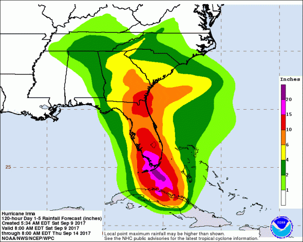
RAINFALL: Irma is expected to produce the following rain accumulations through Wednesday:
- Northern Cuba…10 to 15 inches, isolated 20 inches.
- Southern Cuba…5 to 10 inches, isolated 15 inches.
- Western Bahamas…3 to 6 inches, isolated 10 inches.
- The Florida Keys…10 to 20 inches, isolated 25 inches.
- The Florida peninsula and southeast Georgia…8 to 15 inches, isolated 20 inches.
- The eastern Florida Panhandle…3 to 6 inches, isolated 8 inches.
- Rest of eastern Georgia, western South Carolina, and western North Carolina…4 to 8 inches.
- Western Georgia, eastern and northern Alabama, and southern Tennessee…2 to 5 inches.
In all areas, this rainfall may cause life-threatening flash floods and, in some areas, mudslides.
TORNADOES: A few tornadoes are possible today and tonight over southern Florida.
SURF: Swells generated by Irma are affecting the southeastern Bahamas, the Turks and Caicos Islands and the southeast coast of the United States today. These swells are likely to cause life-threatening surf and rip current conditions. Please consult products from your local weather office.
When to Expect Hurricane Irma and Where
INIT 09/2100Z 23.4N 80.5W 110 KT 125 MPH
12H 10/0600Z 24.1N 81.3W 115 KT 130 MPH 44 miles SE of Key West
24H 10/1800Z 25.7N 82.0W 120 KT 140 MPH 32 miles SW of Naples, FL
————- Landfall Near Capr Coral, FL ———————–
36H 11/0600Z 28.3N 82.6W 100 KT 115 MPH 13 miles SSW of Spring Hill, FL
48H 11/1800Z 31.2N 83.8W 65 KT 75 MPH…INLAND – Moultrie, GA
72H 12/1800Z 35.5N 88.0W 25 KT 30 MPH…POST-TROP/INLAND
96H 13/1800Z 36.1N 89.0W 25 KT 30 MPH…POST-TROP/INLAND
120H 14/1800Z…DISSIPATED