Hurricane Harvey is expected to strengthen into a major hurricane before striking the Texas coast late Friday night or early Saturday. Major Hurricanes pack winds of over 110 mph and should be considered a great threat to life and property. The National Weather Service warns that “preparations along the middle Texas Coast should be rushed to completion today.
National Weather Service update 8-24-17 – 14:00: (for the most up-to-date Harvey coverage, visit our Harvey page)
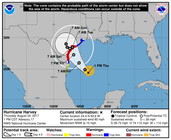
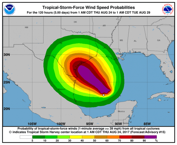
Harvey was last reported at 24.4 N, 93.6W moving north-northwest at 10 mph with maximum sustained winds of 80 mph. The estimated minimum central pressure based on data from NOAA and Air Force Hurricane Hunter aircraft is 979 mb (28.91 inches) and dropping indicating strengthening.
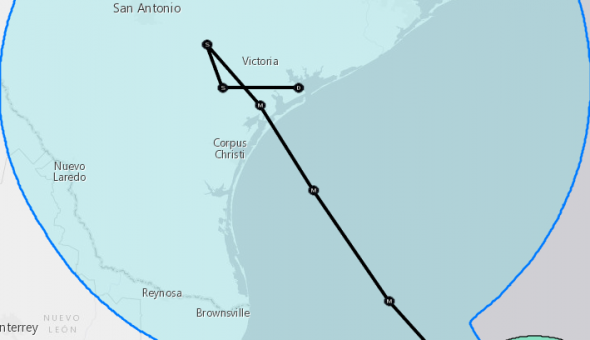
Where will Harvey make landfall
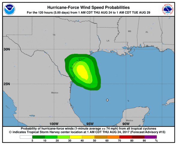
Harvey is currently forecast to make landfall just east of Rockport, TX. Corpus Christi won’t take a direct hit, but hurricane force winds extend out 25 miles from the center and tropical storm winds 90 miles from the center. Maximum sustatained winds are predicted to be from 115 to 120 mph with gusts even stronger.
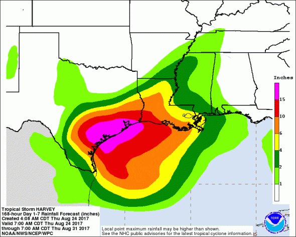
Strong Winds and Tons of Rain
Hurricane force winds will hit the coast as the storm makes landfall and tropical storm force winds are expected along most of southeast Texas. The rainfall potential of this storm is enormous as 15+ inches of rain are expected along much of the Texas Gulf coast and areas just inland. As much as 30 inches of rain could fall in some areas.
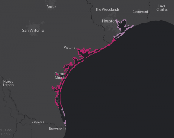
Storm Surge Predections
Storm surge watches and warnings have gone out along most of the Texas coastline.
- North Entrance Padre Island Natl Seashore to Sargent…6 to 10 ft
- Sargent to San Luis Pass…5 to 7 ft
- Port Mansfield to N Entrance Padre Island Natl Seashore…5 to 7 ft
- San Luis Pass to High Island…2 to 4 ft
- Mouth of the Rio Grande to Port Mansfield…2 to 4 ft
- High Island to Morgan City…1 to 3 ft
Harvey Watches and Warnings
A Storm Surge Warning has been issued for the Texas coast from Port Mansfield to San Luis Pass.
A Storm Surge Watch has been issued from Port Mansfield south to the Mouth of the Rio Grande.
A Hurricane Warning has been issued for the Texas coast from Port Mansfield to Matagorda.
A Tropical Storm Warning has been issued from north of Matagorda to High Island Texas
A Tropical Storm Warning and a Hurricane Watch has been issued from south of Port Mansfield to the Mouth of the Rio Grande.
A Storm Surge Watch means there is a possibility of life-threatening inundation, from rising water moving inland from the coastline, in the indicated locations during the next 48 hours.
A Storm Surge Warning means there is a danger of life-threatening inundation, from rising water moving inland from the coastline, during the next 36 hours in the indicated locations. This is a life-threatening situation. Persons
located within these areas should take all necessary actions to protect life and property from rising water and the potential for other dangerous conditions. Promptly follow evacuation and other instructions from local officials.
A Hurricane Watch means that hurricane conditions are possible within the watch area. A watch is typically issued 48 hours before the anticipated first occurrence of tropical-storm-force winds, conditions that make outside preparations difficult or dangerous.
A Hurricane Warning means that hurricane conditions are expected somewhere within the warning area. A warning is typically issued 36 hours before the anticipated first occurrence of tropical-storm-force winds, conditions that make outside preparations difficult or dangerous. Preparations to protect life and property should be rushed to completion.
A Tropical Storm Watch means that tropical storm conditions are possible within the watch area, generally within 48 hours.
A Tropical Storm Warning means that tropical storm conditions are expected somewhere within the warning area within 36 hours.