Latest on Irma
This article is OUTDATED – see all of our Irma coverage HERE.
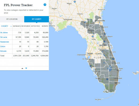
The latest update on Hurricane Irma shows the storm striking the Tampa Bay area in the early hours Monday where the National Weather Service says they should expect a category one storm and 5 – 8 ft storm surge. Almost 3 million people are without power according to Florida Power & Light.
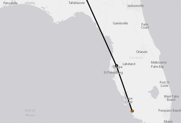
Hurricane Irma’s Current Position and Track
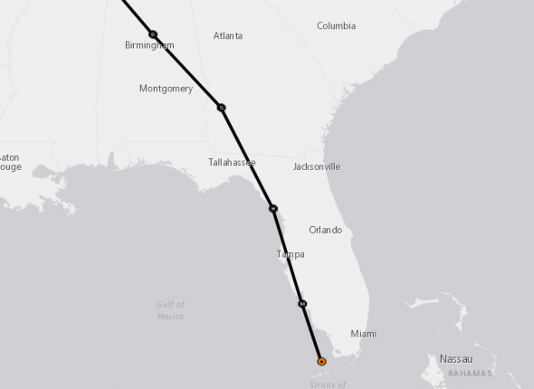
The national weather service is currently forecasting landfall in western Florida. Irma is forecast to head due north and make pass very near Marco Island/Naples and make landfall at Sanibel Island/Ft. Meyers Beach before tracking up the peninsula into Georgia, Alabama, and Tennessee.
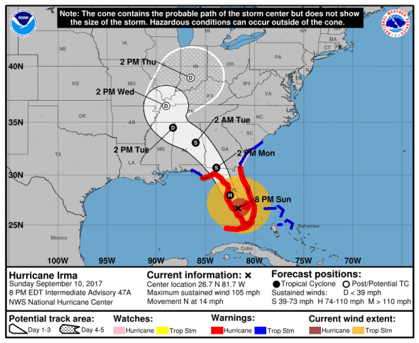
2000 AST/EDT (0000 UTC) Update from National Weather Service
- Location: 26.7N 81.7W 30 miles SE of Port Charlotte, FL
- Strength: 105 mph max sustained winds (Category 2)
- Movement: N (355 deg.) at 14 mph
- Pressure: 942 mb
*next update at 11 pm EDT – check our Irma update page for new information
The latest satellite imagery shows an indistinct eye and eroding organization indicating weakening as more of Irma is over land.
 Irma is a category two storm.
Extremely dangerous winds will cause extensive damage: Well-constructed frame homes could sustain major roof and siding damage. Many shallowly rooted trees will be snapped or uprooted and block numerous roads. Near-total power loss is expected with outages that could last from several days to weeks.
Hurricane-force winds extend outward up to 80 miles (130 km) from the center, and tropical-storm-force winds extend outward up to 220 miles (350 km).
U.S. Impacts
NWS predicts that Irma will strike the western part of Florida.
 Florida
The National Weather Service forecasts Irma to go up through Cape Coral, the Tampa Bay area and up through the panhandle to Georgia.
 Florida has declared a state of emergency and multiple areas have been ordered to evacuate immediately.
Georgia
Georgia has declared a state of emergency. Gov. Nathan Deal issued a mandatory evacuation for all areas east of I-95 and other parts of the state’s coast as Hurricane Irma barrels toward Florida and Georgia with potentially catastrophic force.
South Carolina
South Carolina has declared a state of emergency, coastal areas and barrier islands are under a mandatory evacuation order.
North Carolina
Gov. Roy Cooper has declared a state of emergency for North Carolina. No evacuations have been ordered.
Watches and Warnings
Areas under storm surge warning
* South Santee River southward to Jupiter Inlet
* North Miami Beach southward around the Florida peninsula to the
Ochlockonee River
* Florida Keys
* Tampa Bay
Areas under storm surge watch
* None
Areas under Hurricane Warning
* Fernandina Beach southward around the Florida peninsula to Indian
Pass
* Florida Keys
* Lake Okeechobee
* Florida Bay
Areas under Hurricane Watch
* North of Fernandina Beach to Edisto Beach
Areas under Tropical Storm Warning
* West of Indian Pass to the Okaloosa/Walton County Line
* North of Fernandina Beach to South Santee River
Areas under Tropical Storm Watch
* Bimini and Grand Bahama
What to Expect from Hurricane Irma
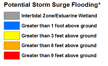
STORM SURGE: The combination of a dangerous storm surge and the tide will cause normally dry areas near the coast to be flooded by rising waters moving inland from the shoreline. The water is expected to reach the following HEIGHTS ABOVE GROUND if the peak surge occurs at the time of high tide…
- Cape Sable to Captiva…10 to 15 ft
- Captiva to Ana Maria Island…6 to 10 ft
- Card Sound Bridge through Cape Sable, including the Florida Keys…5 to 10 ft
- Ana Maria Island to Clearwater Beach, including Tampa Bay…5 to 8 ft
- North Miami Beach to Card Sound Bridge, including Biscayne Bay…3 to 5 ft
- South Santee River to Fernandina Beach…4 to 6 ft
- Clearwater Beach to Ochlockonee River…4 to 6 ft
- Fernandina Beach to Jupiter Inlet…2 to 4 ft
- North of North Miami Beach to Jupiter Inlet…1 to 2 ft
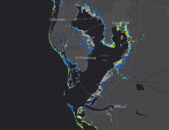
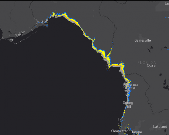
The deepest water will occur along the immediate coast in areas of onshore winds, where the surge will be accompanied by large and destructive waves. Surge-related flooding depends on the relative timing of the surge and the tidal cycle, and can vary greatly over short distances. For information specific to your area, please see products issued by your local National Weather Service forecast office.
The combination of a life-threatening storm surge and large breaking waves will raise water levels ABOVE NORMAL TIDE LEVELS by the following amounts within the hurricane warning area near and to the north of the center of Irma. Near the coast, the surge will be accompanied by large and destructive waves.
WIND: Hurricane conditions are expected to continue within the hurricane warning area along the north coast of Cuba through this morning. Hurricane conditions are continuing across portions of the Florida Keys and southern Florida. Winds affecting the upper floors of high-rise buildings will be significantly stronger than those near ground level. Tropical storm and hurricane conditions are expected to spread northward across the remainder of the warning
areas through Monday. Tropical storm conditions are possible in the watch area in the Northwestern Bahamas today.
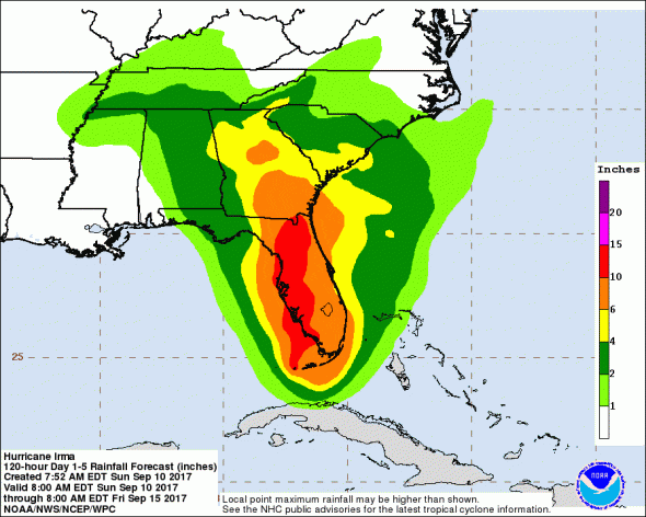
RAINFALL: Irma is expected to produce the following rain accumulations through Wednesday:
- Western Bahamas…Additional 2 to 4 inches, isolated 6 inches.
- The Florida Keys…Additional 3 to 6 inches with storm total amounts from 15 to 20 inches, isolated 25 inches.
- Western Florida peninsula…10 to 15 inches, isolated 20 inches.
- Eastern Florida peninsula and southeast Georgia…8 to 12 inches, isolated 16 inches.
- The rest of Georgia, the eastern Florida Panhandle, southern and western South Carolina, and western North Carolina…3 to 8 inches, isolated 12 inches.
- Southern Tennessee, northern Mississippi and much of Alabama…2 to 5 inches.
In all areas, this rainfall may cause life-threatening flash floods and, in some areas, mudslides.
TORNADOES: A few tornadoes are possible today and tonight over southern Florida.
THE EYE: Do not venture outside when the calm eye of the hurricane passes over, as dangerous winds will return very quickly when the eye moves away.
SURF: Swells generated by Irma are affecting the southeast coast of the United States. These swells are likely to cause life- threatening surf and rip current conditions. Please consult products from your local weather office.
When to Expect Hurricane Irma and Where
INIT 10/2100Z 26.2N 81.8W 95 KT 110 MPH…INLAND (5p EDT)
12H 11/0600Z 28.0N 82.5W 75 KT 85 MPH…INLAND – 5 miles NW of Tampa (2a EDT)
24H 11/1800Z 30.7N 83.9W 55 KT 65 MPH…INLAND – 11 miles SE of Thomasville, GA (2p EDT)
36H 12/0600Z 33.1N 86.0W 35 KT 40 MPH…INLAND (2a EDT)
48H 12/1800Z 34.5N 88.3W 30 KT 35 MPH…INLAND
72H 13/1800Z 36.5N 89.0W 25 KT 30 MPH…POST-TROP/INLAND
96H 14/1800Z 39.0N 86.5W 20 KT 25 MPH…POST-TROP/INLAND
120H 15/1800Z…DISSIPATED