Gordon makes landfall near Mississippi-Alabama border as strong tropical storm, 31,000 without power – 11pm update
Updated 9-4-18 23:00 ET

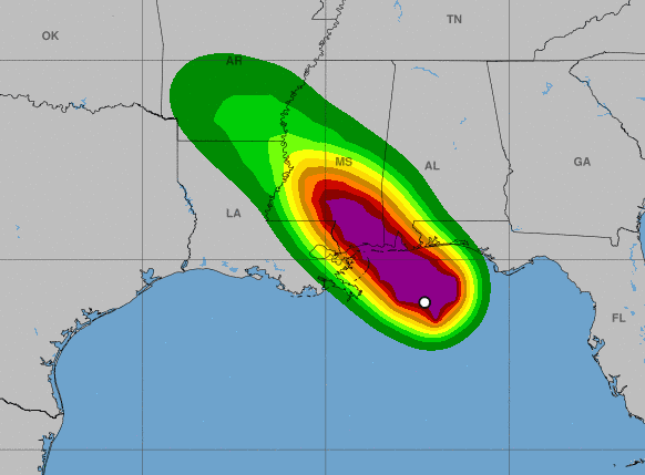
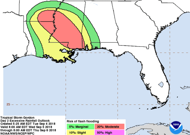
Tropical Storm Gordon will dump 4-8 inches of rain in some parts of Alabama, Florida and Mississippi, with 12 inches possible in isolated areas. The northern edge of the storm’s center is overland just west of the Mississippi border with winds of 70 mph and Gordon is beginning to cause massive power outages in Alabama and some in Mississippi.
Alabama is reporting that almost 27,000 customers are without power and another 4,000 are out in Mississippi. Outages are being reported along the Southwest Alabama coast and the Southeast Mississippi coast.
Location/Strength
Current data:
Location: 30.3N 88.4W – 30 miles ESE of Biloxi, Mississippi
Movement: NW (315º) @ 14 mph
Strength: 70 mph
Pressure: 997 mb and dropping
Forecast position/strength
INIT  05/0300Z 30.3N  88.4W   60 KT  70 MPH
 12H  05/1200Z 31.5N  89.6W   35 KT  40 MPH...INLAND
 24H  06/0000Z 32.7N  90.9W   25 KT  30 MPH...INLAND
 36H  06/1200Z 33.5N  92.0W   25 KT  30 MPH...INLAND
 48H  07/0000Z 34.3N  92.9W   20 KT  25 MPH...POST-TROP/REMNT LOW
 72H  08/0000Z 36.0N  93.9W   20 KT  25 MPH...POST-TROP/REMNT LOW
 96H  09/0000Z 38.3N  92.0W   20 KT  25 MPH...POST-TROP/REMNT LOW
120H  10/0000Z 41.0N  88.5W   20 KT  25 MPH...POST-TROP/EXTRATROP
Storm Surge/Flooding
Some coastal flooding is likely as the storm surge is forecast to be 3+ feet in the St. Louis Bay, Pass Christian, Long Beach and Gulfport areas of Mississippi in addition to the heavy rains.
The combination of a dangerous storm surge and the tide will cause normally dry areas near the coast to be flooded by rising waters moving inland from the shoreline. The water could reach the following heights above ground somewhere in the indicated areas if the peak surge occurs at the time of high tide:
- Shell Beach to Dauphin Island…3 to 5 ft.
- Navarre Florida to Dauphin Island, including Mobile Bay…2 to 4 ft.
- Shell Beach to the Mouth of Mississippi River…2 to 4 ft.
- Mouth of the Mississippi River to the Louisiana-Texas border…1 to 2 ft.
The National Weather Service has issued a storm surge warning from Shell Beach, Louisiana, to Dauphin Island. A storm surge watch has been issued from West of Shell Beach to the mouth of the Mississippi River and from East of Dauphin Island to Navarre.
A Storm Surge Warning means there is a danger of life-threatening inundation, from rising water moving inland from the coastline, during the next 36 hours in the indicated locations. For a depiction of areas at risk, please see the National Weather Service Storm Surge Watch/Warning Graphic, available at hurricanes.gov. This is a life-threatening situation. Persons located within these areas should take all necessary actions to protect life and property from rising water and the potential for other dangerous conditions. Promptly follow evacuation and other instructions from local officials.
A Storm Surge Watch means there is a possibility of life- threatening inundation, from rising water moving inland from the coastline, in the indicated locations.
Winds
Winds are expected to be strongest at the Mississippi – Alabama border where forecasts show a high probability of sustained winds reaching tropical storm force (up to 39 mph.) Areas along the Mississippi coast could see maximum sustained winds of up to 58 mph and guts higher than that.