Latest on Irma
The newest National Weather Service forecast predicts catastrophic track for Hurricane Irma so Florida and Georgia have issued new evacuation orders for certain areas of those states.
This post is OUTDATED, follow our latest Irma coverage HERE.
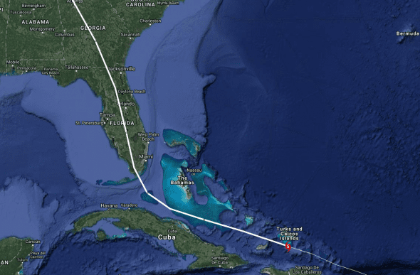
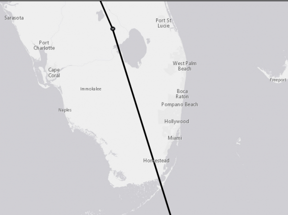
Hurricane Irma’s Current Position and Track
The national weather service is currently forecasting landfall in southeastern Florida just south of Miami – the worst possible landfall for Florida’s most populous city and the storm may arrive with borderline category five winds.
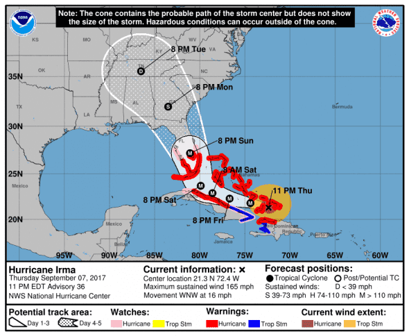
2300 AST/EDT (0300 UTC) Update from National Weather Service
- Location: 21.5 N, 73.3 W – 122 miles WNW of MOA, Cuba
- Strength: 160 mph max sustained winds (Category 5)
- Movement: WNW (290 deg.) at 16 mph
- Pressure: 925 mb, 5 mb increase from last update which may indicate weakening
*next update at 6am EDT – check our Irma update page for new information
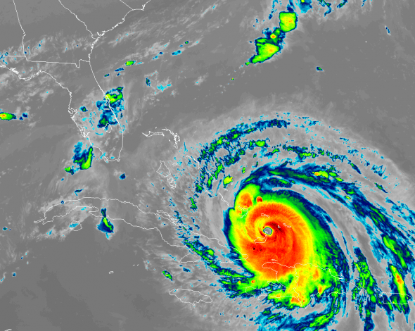
The latest satellite imagery shows the clearly defined eyewall and strong outflow expected from a storm of this intensity.
Irma is a strong category five storm but is expected to weaken to a maximum intensity category four hurricane or low-end category five with 150 to 160 mph winds over the next 2-3 days hours as it skirts Cuba and the Bahamas before making landfall in Florida.
Catastrophic damage will occur: A high percentage of framed homes will be destroyed, with total roof failure and wall collapse. Fallen trees and power poles will isolate residential areas. Power outages will last for weeks to possibly months. Most of the area will be uninhabitable for weeks or months.
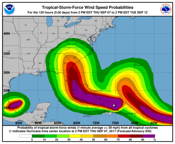
Hurricane-force winds extend outward up to 70 miles (110 km) from the center and tropical-storm-force winds extend outward up to 185 miles (295 km).
Computer Models for Hurricane Irma
Computer models are closing in on an east Florida solution. Irma is going to, in one way or antoher, be catastrophic for the Sunshine State.
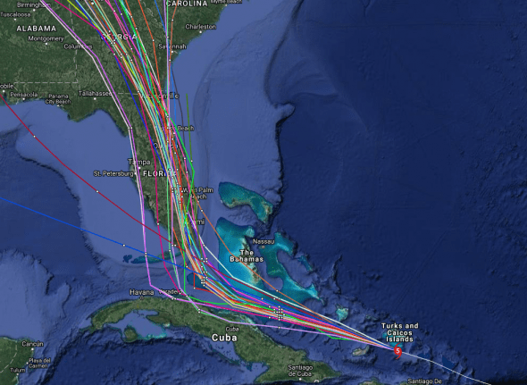
Early cycle model consensus forecasts that Irma will ride up the center of the Florida peninsula – a nightmare scenario for the state.
The late cycle model consensus forecasts a path even more dangerous for Floridians as it puts the eye over Orlando and Jacksonville after a direct hit on Miami.
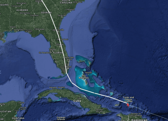
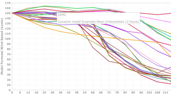
The intensity models are all over the place so Irma’s strength as she approaches Florida is in question.
U.S. Impacts
The current U.S. portion of Irma’s track shows a glancing blow near Miami and a track straight up the peninsula and through Georgia.
Florida
The National Weather Service forecasts a direct hit to southeast Florida south of Miami.
Florida has declared a state of emergency and multiple areas have been ordered to evacuate immediately.
- Miami Dade has issued mandatory evacuations for all of Zone A, the Barrier Islands of Zone B, and all mobile homes. Miami Dade residents can find their zones by clicking HERE.
- Broward County has issued voluntary evacuations of mobile homes and low-lying areas.
- Collier County has issued voluntary evacuations of Marco Island.
- Monroe County has issued mandatory evacuations for visitors and residents. A dedicated transportation hotline is available specifically for individuals in the Keys at 305-517-2480.
- School buses are available for transportation needs in Monroe, Miami-Dade and Broward counties. At this time, Miami-Dade is using these services to help evacuate those with special needs and Broward has buses on stand-by.
- Additional evacuations are expected throughout the state. All Floridians should pay close attention to local alerts and follow the directions of local officials.
- Shelters are opening in coastal counties throughout the day, including shelters for people with special needs, pets and general populations. DOH is coordinating the set up and staffing for special needs shelters. A list of all open shelters will be available at floridadisaster.org/shelters.
- The state is working with the American Red Cross to identify shelter capacity both during and following the storm.
Floridians should start preparing now to either shelter-in-place or evacuate. If Irma tracks towards Florida, additional evacuations will likely be posted. Don’t wait until the last minute and please listen to local authorities for instructions.
Georgia
Georgia has declared a state of emergency. Gov. Nathan Deal issued a mandatory evacuation order Thursday for all areas east of I-95 and other parts of the state’s coast as Hurricane Irma barrels toward Florida and Georgia with potentially catastrophic force.
“I encourage all Georgians in our coastal areas that could be impacted by this storm to evacuate the area as soon as possible,” said Deal.
South Carolina
South Carolina has declared a state of emergency, no evacuation orders are in place.
Governor Henry McMaster said that residents should start preparations for Irma as if she were coming tomorrow.
“Now is the time to prepare,” McMaster warned during a news conference at the S.C. Emergency Management Division headquarters on Wednesday. “When it’s too late, it’s too late and that’s when we have a lot sadness.”
North Carolina
Gov. Roy Cooper has declared a state of emergency for North Carolina. No evacuations have been ordered.
Watches and Warnings
Areas under storm surge watch
* Jupiter Inlet southward around the Florida peninsula to Bonita
Beach
* Florida Keys
Areas under Hurricane Warning
* Dominican Republic from Cabo Frances Viejo to the northern border
with Haiti
* Haiti from the northern border with the Dominican Republic to Le
Mole St. Nicholas
* Southeastern Bahamas and the Turks and Caicos Islands
* Cuban provinces of Camaguey, Ciego de Avila, Sancti Spiritus, and
Villa Clara
* Central Bahamas
* Northwestern Bahamas
Areas under Hurricane Watch
* Jupiter Inlet southward around the Florida peninsula to Bonita
Beach
* Florida Keys
* Lake Okeechobee
* Florida Bay
* Cuban provinces of Guantanamo,Holguin, Las Tunas and Matanzas.
Areas under Tropical Storm Warning
* Dominican Republic from south of Cabo Engano westward to the
southern border with Haiti
* Haiti from south of Le Mole St. Nicholas to Port-Au-Prince
* Cuban provinces of Guantanamo, Holguin, Las Tunas.
Areas under Tropical Storm Watch
* None
What to Expect from Hurricane Irma
STORM SURGE: The combination of a dangerous storm surge and the tide will cause normally dry areas near the coast to be flooded by rising waters moving inland from the shoreline. The water is expected to reach the following HEIGHTS ABOVE GROUND if the peak surge occurs at the time of high tide…
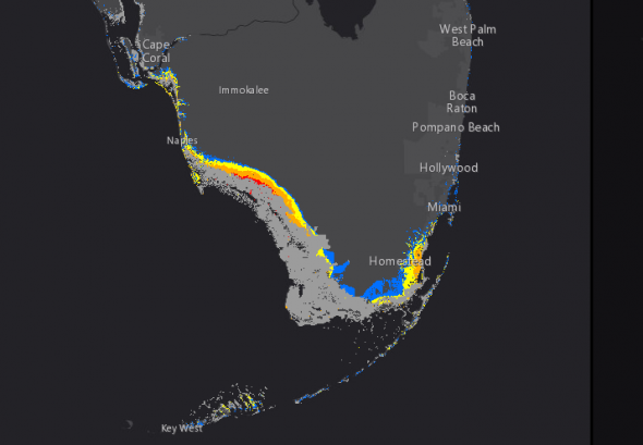
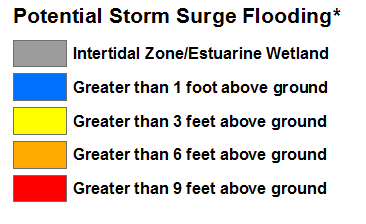
Jupiter Inlet to Bonita Beach, including Florida Keys…5 to 10 ft
The deepest water will occur along the immediate coast in areas of onshore winds, where the surge will be accompanied by large and destructive waves. Surge-related flooding depends on the relative timing of the surge and the tidal cycle, and can vary greatly over short distances. For information specific to your area, please see products issued by your local National Weather Service forecast office.
The combination of a life-threatening storm surge and large breaking waves will raise water levels ABOVE NORMAL TIDE LEVELS by the following amounts within the hurricane warning area near and to the north of the center of Irma. Near the coast, the surge will be accompanied by large and destructive waves.
- Turks and Caicos Islands…15 to 20 ft
- Southeastern and central Bahamas…15 to 20 ft
- Northwestern Bahamas…5 to 10 ft
- Northern coast of the Dominican Republic…3 to 5 ft
- Northern coast of Haiti and the Gulf of Gonave…1 to 3 ft
- Northern coast of Cuba in the warning area…5 to 10 ft
WIND: Hurricane conditions are expected to continue within the hurricane warning area in the Dominican Republic and Haiti tonight. Hurricane conditions already affecting the Turks and Caicos Islands. Tropical storm and hurricane conditions are beginning in the southeastern Bahamas and will spread into the central Bahamas by tonight or early Friday. Hurricane conditions are expected within the hurricane warning area along the north coast of Cuba late
Friday and Saturday. Hurricane conditions are expected in the northwestern Bahamas Friday night and Saturday.
Hurricane conditions are possible within the watch area in Florida by Sunday, with tropical storm conditions possible by late Saturday.
RAINFALL: Irma is expected to produce the following rain accumulations through Saturday evening:
- Northeast Puerto Rico and the British and U.S. Virgin Islands… additional 1 to 2 inches
- Much of the Bahamas and Turks and Caicos…8 to 12 inches, isolated 20 inches
- Andros Island and Bimini, Bahamas…12 to 16 inches, isolated 25 inches
- Northern Dominican Republic and northern Haiti…4 to 10 inches, isolated 15 inches
- Southern Dominican Republic and southern Haiti…2 to 5 inches
- Eastern and central Cuba…4 to 10 inches, isolated 15 inches
- Southeast Florida and the upper Florida Keys…8 to 12 inches, isolated 20 inches
- Lower Florida Keys…2 to 5 inches
In all areas this rainfall may cause life-threatening flash floods and mudslides.
SURF: Swells generated by Irma are affecting the northern Leeward Islands, Puerto Rico, the Virgin Islands, the southeastern Bahamas, the Turks and Caicos Islands, the northern coast of the Dominican Republic, and should start affecting portions of the southeast coast of the United States later today and tonight. These swells are likely to cause life-threatening surf and rip current conditions. Please consult products from your local weather office.
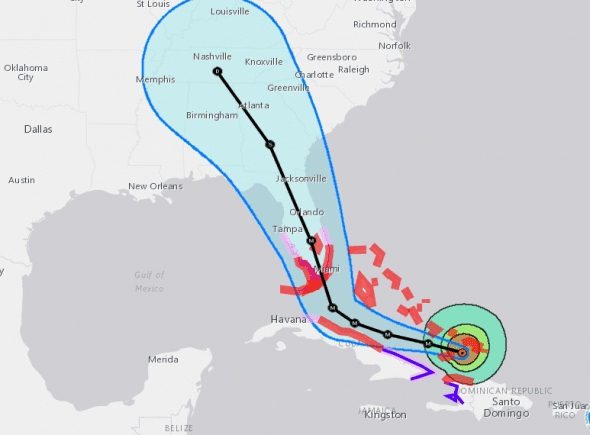
When to Expect Hurricane Irma and Where
INIT 08/0300Z 21.3N 72.4W 145 KT 165 MPH
12H 08/1200Z 21.8N 74.4W 145 KT 165 MPH – 103 Miles NE of Banes, Cuba
24H 09/0000Z 22.3N 76.7W 140 KT 160 MPH – 114 miles SE of The Bahamas
36H 09/1200Z 22.9N 78.6W 135 KT 155 MPH – 222 miles SE of Miami, FL
48H 10/0000Z 23.7N 79.9W 135 KT 155 MPH – 142 miles from Miami, FL
57H 10/0900Z —- Landfall Florida —–
72H 11/0000Z 27.2N 81.1W 100 KT 115 MPH…INLAND – 44 miles west of Port St. Lucie
96H 12/0000Z 32.0N 83.5W 50 KT 60 MPH…INLAND – 57 miles south of Macon, GA
120H 13/0000Z 35.5N 86.5W 30 KT 35 MPH…INLAND – 49 miles SSW of Nashville, TN


According to local reports Western Montana has over 1600 individual Forest Fires that are clumped together and Named as about 45 major fires. According to the general report nearly all were caused by lightening strikes.
Montana has just over 4000 fire fighters including volunteers. They have relatively little outside help with the MT National Guard only acting as police in evacuated areas. According to the Gov’s Office the State has paid out 53mil. while the government pays a 75% share of expense or almost 160mil. But so far the fires have cost 284mil. just to fight. And the State is out of money (partly because the Gov has spent Fire Fighting funds on other projects and expenses prior to the fires). The Bucket Aircraft are grounded and the State is spiraling into deep dept. Community after community is being evacuated! There is no report yet on property damage – expect 10s or 100s of millions. Two fire fighters have died.
Funds from FEMA are restricted from human caused fires.
The claim that most of the fires are lightening strikes appear to be false according to actual investigation and indeed there have only been a few dry thunderstorms over the last several months. Every year there are major Forest Fires in the National Forests of the State (very few on State owned land). But nothing like this; this is wholesale. Montana is the 4th largest State so one might argue; “well it covers a lot of area”. Good argument – except that there are no fires in the eastern half of MT and even in the worst years past it was never ALL OVER Western MT like this. Actual investigation indicates well over half – nearly 1000 – of the fires were caused by human activity.
Human ACTIVITY? This isn’t all negligence or accidental! This is ECO TERRORISM. First the federal government refuses to sell logging permits and has actively destroyed that industry in Western States where they ILLEGALLY (contrary the Fed. Agreements with newly formed States) continue to own land. Then they do not manage and maintain the forests to prevent fires from happening or at least when they do happen are far easier to fight. Western State Forests are in horrible shape literally tender boxes waiting for a spark! The terrain is often so rugged and inaccessible (since the Feds love to close down logging access roads) that the some fires cannot be reached even by air. Most of the fires are being allowed to burn and are only watched by one or two individuals – never mind all that EVIL CO2 being spewed into the precious clean atmosphere! On average the costs of fire fighting and the lawsuits afterwards cost the government over 8.00 per acre while management would cost a couple of bucks each and would actually turn a profit if Logging, Mining and Grazing were allowed as they once had been!
So how much of Montana’s massive fire problem have you heard about in the Mainstream Media? Every evening, right? You’ve heard about Oregon and Californication, Right. MT is right up there with the rest of them EVERY evening right? Right up there with Harvey and Irma – Right?! RIGHT?!! HARDLY!!!!
Montanans feel for the people of the south eastern States affected by Hurricanes and flooding and have generously donated to charities dedicated to helping. But here is the thing; hurricanes, flooding, earth quakes, tsunamis, tornados, and volcanic eruptions – and even some forest fires occur naturally and there isn’t anything humans have done to cause them (Human caused climate change is a FLAT OUT LIE!! Scientific data has proven that OVER and OVER) nor is there anything Humans can do to prevent them. But ALL of the blame for National Forest Fires in MT, OR, WA, CA, and others rests SQUARELY upon the shoulders of our FEDERAL “DEEP STATE” bureaucracy. THEY have built the explosive tender boxes over the last 35 years and they have imported and indoctrinated anti-American activists to make “good” use of them!!
But the loving, objective, compassionate MSM says NOTHING!!! Now as Montanans cut thru the smoke that looks like fog and smell like poison for nearly 3 months on end JUST to see if the sun is still shining pour out their hearts to the victims of Harvey and Irma and whatever else!
Me, personally; KMA!!!
finally, the hypocrisies of the Federal Government and all of the algorian Eco soothsayers is that; EASTERN STATES pay for the welfare of Western States!! Greenhouse gases, fraudulent as they are represented by the high priest of “Green”, are being created in the NAME of anti-human “Green” (there are actually lawsuits being filed against the State for FIGHTING the fires!!!). The new color of the religion of “Mother Earth” is CHARCOAL!!! GIVE the Western States THEIR LAND, federal Gov. YOU SUCK at managing it!