Harvey could slam Texas as powerful Category 4 Hurricane
Hurricane Harvey is expected to strengthen into a category 3 hurricane Friday morning and will strike the Texas coast late Friday night or early Saturday as a strong category 3 or perhaps a category 4 storm. The National Weather Service warns that “life-threatening and devastating flooding expected near the coast due to heavy rainfall and storm surge.”. Major Hurricanes pack winds of over 110 mph and should be considered a great threat to life and property.
National Weather Service update 8-24-17 – 22:00 CT: (for our complete Harvey coverage, visit our Harvey page)
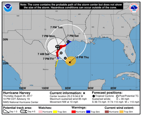
Harvey was last reported at 25.2 N, 94.6W moving northwest at 10 mph with maximum sustained winds of 85 mph. The estimated minimum central pressure based on data from NOAA and Air Force Hurricane Hunter aircraft is 973 mb (28.74 inches) and dropping indicating strengthening.
Computer Models Predict Worst Case
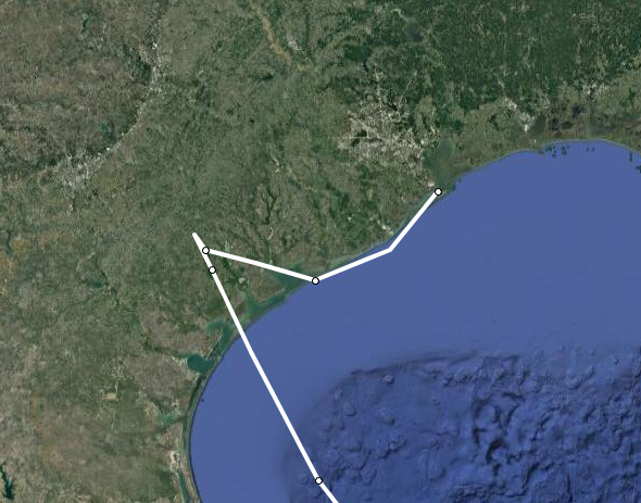
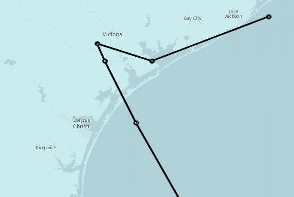
Several computer forecast models are predicting a worst-case scenario for the Texas coast. After making landfall, the storm is expected to stick around near Corpus Christie, go offshore and re-strengthen as it travels along the Texas coastline just offshore wreaking havoc and dropping tons of rain as it makes a beeline for Galveston.
The National Weather service chose a set of models that shows a slightly different track, but with the same outcome. A storm tracking up the Texas coast for days.
What are Category 3 and Category 4 Hurricanes
The storm categories come from the Saffir-Simpson Hurricane Wind Scale designed to relay the magnitude of a storm’s impact.
Category 3 storms have maximum sustained winds of 110 to 130 mph and according to the Saffir-Simpson Scale:
These storms can cause some structural damage to small residences and utility buildings, particularly those of wood frame or manufactured materials with minor curtain wall failures. Buildings that lack a solid foundation, such as mobile homes, are usually destroyed, and gable-end roofs are peeled off. Manufactured homes usually sustain severe and irreparable damage. Flooding near the coast destroys smaller structures, while larger structures are struck by floating debris. A large number of trees are uprooted or snapped, isolating many areas. Additionally, terrain may be flooded well inland. Near-total to total power loss is likely for up to several weeks and water will likely also be lost or contaminated.
Category 4 storms have maximum sustained winds of 131 to 155 mph and:
produce more extensive curtainwall failures, with some complete structural failure on small residences. Heavy, irreparable damage and near complete destruction of gas station canopies and other wide span overhang type structures are common. Mobile and manufactured homes are often flattened. Most trees, except for the heartiest, are uprooted or snapped, isolating many areas. These storms cause extensive beach erosion, while terrain may be flooded far inland. Total and long-lived electrical and water losses are to be expected, possibly for many weeks.
Where will Harvey make landfall
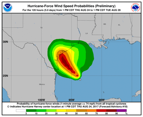
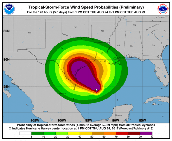
Harvey is currently forecast to make landfall just east of Rockport, TX. Corpus Christi won’t take a direct hit according to current forecasts, but the storm will stay in the area for days. Hurricane force winds extend out 25 miles from the center and tropical storm winds 90 miles from the center. Maximum sustained winds are predicted to be from 115 to 120 mph with gusts even stronger.
After 120 hours onshore, Harvey is expected to return to the Gulf of Mexico:
48H 26/1800Z 28.5N 97.1W 85 KT 100 MPH…INLAND
72H 27/1800Z 28.7N 97.2W 45 KT 50 MPH…INLAND
96H 28/1800Z 28.5N 96.5W 35 KT 40 MPH…INLAND
120H 29/1800Z 29.0N 95.0W 35 KT 40 MPH…OVER WATER
Strong Winds and Tons of Rain
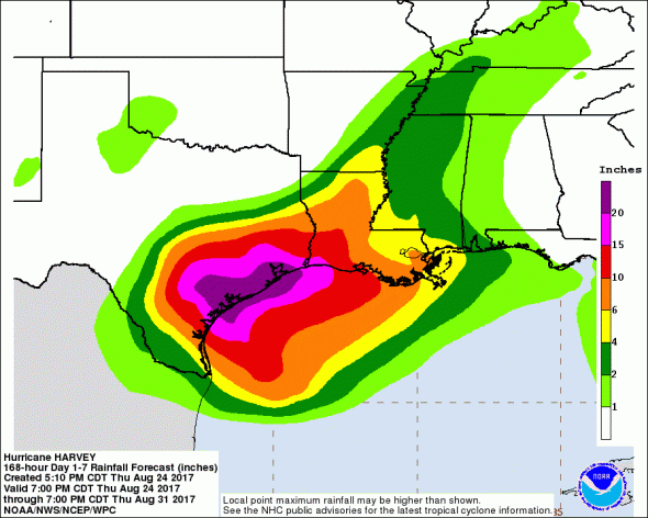
Hurricane force winds will hit the coast as the storm makes landfall and tropical storm force winds are expected along most of southeast Texas. The rainfall potential of this storm is enormous as 20+ inches of rain are expected along much of the Texas Gulf coast and areas just inland. As much as 36 inches of rain could fall in some areas.
Storm Surge Predictions
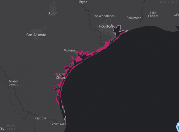
Storm surge watches and warnings have gone out along most of the Texas coastline.
- North Entrance Padre Island Natl Seashore to Sargent…6 to 10 ft
- Sargent to San Luis Pass…5 to 7 ft
- Port Mansfield to N Entrance Padre Island Natl Seashore…5 to 7 ft
- San Luis Pass to High Island…2 to 4 ft
- Mouth of the Rio Grande to Port Mansfield…2 to 4 ft
- High Island to Morgan City…1 to 3 ft
Harvey Watches and Warnings
A Storm Surge Warning has been issued for the Texas coast from Port Mansfield to Sargent, Tx.
A Storm Surge Watch has been issued from Port Mansfield south to the Mouth of the Rio Grande.
A Hurricane Warning has been issued for the Texas coast from Port Mansfield to Sargent, Tx.
A Tropical Storm Warning has been issued from north of Matagorda to High Island Texas
A Tropical Storm Warning and a Hurricane Watch has been issued from south of Port Mansfield to the Mouth of the Rio Grande.
A Storm Surge Watch means there is a possibility of life-threatening inundation, from rising water moving inland from the coastline, in the indicated locations during the next 48 hours.
A Storm Surge Warning means there is a danger of life-threatening inundation, from rising water moving inland from the coastline, during the next 36 hours in the indicated locations. This is a life-threatening situation. Persons
located within these areas should take all necessary actions to protect life and property from rising water and the potential for other dangerous conditions. Promptly follow evacuation and other instructions from local officials.
A Hurricane Watch means that hurricane conditions are possible within the watch area. A watch is typically issued 48 hours before the anticipated first occurrence of tropical-storm-force winds, conditions that make outside preparations difficult or dangerous.
A Hurricane Warning means that hurricane conditions are expected somewhere within the warning area. A warning is typically issued 36 hours before the anticipated first occurrence of tropical-storm-force winds, conditions that make outside preparations difficult or dangerous. Preparations to protect life and property should be rushed to completion.
A Tropical Storm Watch means that tropical storm conditions are possible within the watch area, generally within 48 hours.
A Tropical Storm Warning means that tropical storm conditions are expected somewhere within the warning area within 36 hours.

