Latest on Irma
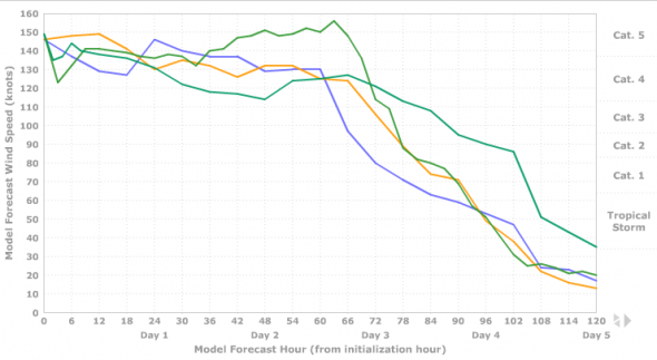
Supercomputers are still struggling to nail down the path of Category 5 Hurricane Irma leaving forecasters with multiple possibilities for the storm’s track and intensity as she nears the Florida Straights and the U.S. Southeastern coast. The storm was supposed to begin weakening more than 36 hours ago and has only now dropped to 175 mph.
This post is OUTDATED – Find our current Irma coverage HERE.
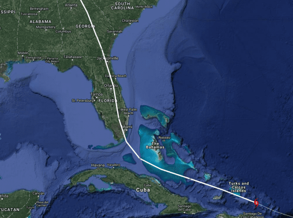
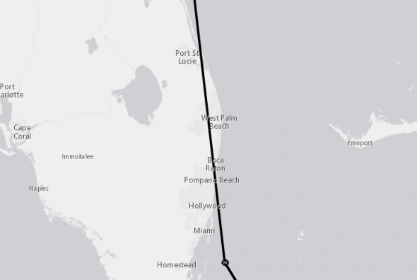
Hurricane Irma’s Current Position and Track
That national weather service is currently forecasting landfall in southeastern Florida somewhere near the West Palm Beach area with a second landfall close to the Georgia-South Carolina border and the latest computer models show a similar track.
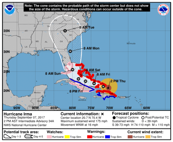
1400 AST/EDT (1800 UTC) Update from National Weather Service
- Location: 20.7 N, 70.4 W – 72 miles southeast of Turks and Caicos
- Strength: 175 mph max sustained winds (Very Strong Category 5)
- Movement: WNW (290 deg.) at 16 mph
- Pressure: 922 mb, 1 mb increase from last update which may indicate weakening
*next update at 5 pm EDT – check our Irma update page for new information
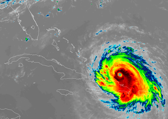
The latest satellite imagery shows the clearly defined eyewall and strong outflow expected from a storm of this intensity.
Irma is a very strong category five storm but is expected to weaken to a category four hurricane with 145 mph winds over the next 72 hours as it skirts the Dominican Republic and the Bahamas before approaching Florida.
Catastrophic damage will occur: A high percentage of framed homes will be destroyed, with total roof failure and wall collapse. Fallen trees and power poles will isolate residential areas. Power outages will last for weeks to possibly months. Most of the area will be uninhabitable for weeks or months.
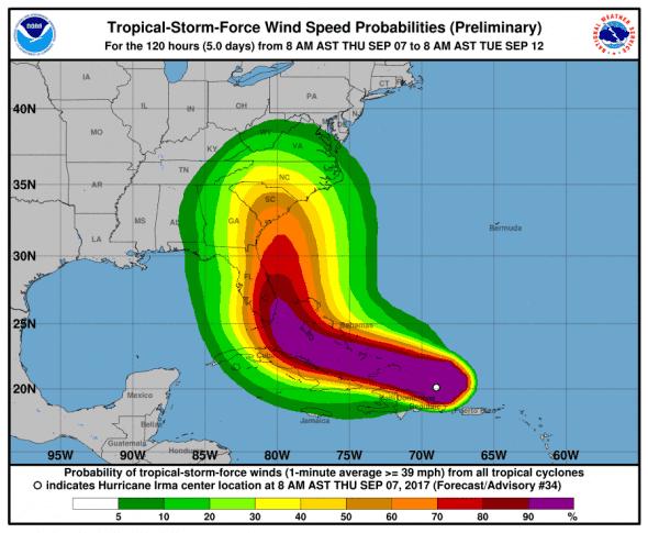
Hurricane-force winds extend outward up to 60 miles (95 km) from the center and tropical-storm-force winds extend outward up to 185 miles (295 km).
Computer Models for Hurricane Irma
Computer models are widely varied as to Irma’s track through the Florida straights and near Florida. The timing of the storm’s northward turn is uncertain which could lead to a Florida landfall or hold Irma to the east of Florida. Secondarily, a Georgia or South Carolina landfall is almost certain.
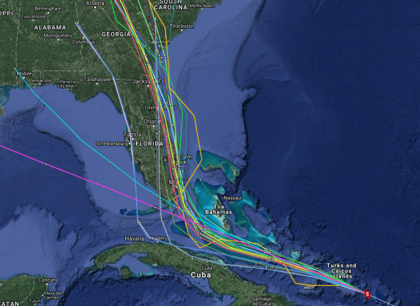
Early cycle model consensus has returned to a track we last saw two days ago where the storm makes landfall south of Miami and travels up the Florida peninsula and into Georgia.
The late cycle model consensus has also moved westward showing a direct hit to Miami and staying on shore across more of southeast Florida than the NWS forecast.
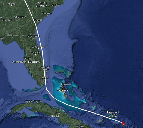
The intensity models are almost all showing a steadily weakening storm as it approaches Florida.
U.S. Impacts
The current U.S. portion of Irma’s track shows a glancing blow near West Palm Beach, Florida and a landfall right on the in Georgia.
Florida
The National Weather Service forecasts a direct hit to southeast Florida around Pompano Beach.
Florida has declared a state of emergency and evacuations are ordered for the Florida Keys and a portion of Broward County. If the forecast continues to show Miami as the landfall location, expect more evacuation orders for southeast Florida.
Broward County Mayor Barbara Sharief said Wednesday that mandatory evacuations have been issued starting at noon Thursday for all residents east of U.S. Route 1, known as Federal Highway, including all barrier islands.
Miami-Dade County is evacuating those with special needs.
Floridians should start preparing now to either shelter-in-place or evacuate. If Irma tracks towards Florida, additional evacuations will likely be posted. Don’t wait until the last minute and please listen to local authorities for instructions.
Georgia
Georgia has declared a state of emergency. No evacuation orders are in place. Atlanta area hotels have begun filling up as those in low-lying areas seek shelter.
South Carolina
South Carolina has declared a state of emergency, no evacuation orders are in place.
Governor Henry McMaster said that residents should start preparations for Irma as if she were coming tomorrow.
“Now is the time to prepare,” McMaster warned during a news conference at the S.C. Emergency Management Division headquarters on Wednesday. “When it’s too late, it’s too late and that’s when we have a lot sadness.”
North Carolina
Gov. Roy Cooper has declared a state of emergency for North Carolina. No evacuations have been ordered.
Watches and Warnings
Areas under storm surge watch
* Jupiter Inlet southward around the Florida peninsula to Bonita
Beach
* Florida Keys
Areas under Hurricane Warning
* Dominican Republic from Cabo Engano to the northern border with
Haiti
* Haiti from the northern border with the Dominican Republic to Le
Mole St. Nicholas
* Southeastern Bahamas and the Turks and Caicos Islands
* Central Bahamas
* Northwestern Bahamas
Areas under Hurricane Watch
* Jupiter Inlet southward around the Florida peninsula to Bonita
Beach
* Florida Keys
* Lake Okeechobee
* Florida Bay
* Cuba from Matanzas province eastward to Guantanamo province
Areas under Tropical Storm Warning
* Dominican Republic from south of Cabo Engano westward to the
southern border with Haiti
* Haiti from south of Le Mole St. Nicholas to Port-Au-Prince
* Cuba provinces of Guantanamo, Holguin, Las Tunas, Camaguey, Ciego
de Avila, Sancti Spiritus and Villa Clara.
Areas under Tropical Storm Watch
* None
What to Expect from Hurricane Irma
STORM SURGE: The combination of a dangerous storm surge and the tide will cause normally dry areas near the coast to be flooded by rising waters moving inland from the shoreline. The water is expected to reach the following HEIGHTS ABOVE GROUND if the peak surge occurs at the time of high tide…
Jupiter Inlet to Bonita Beach, including Florida Keys…5 to 10 ft
The deepest water will occur along the immediate coast in areas of onshore winds, where the surge will be accompanied by large and destructive waves. Surge-related flooding depends on the relative timing of the surge and the tidal cycle, and can vary greatly over short distances. For information specific to your area, please see products issued by your local National Weather Service forecast office.
The combination of a life-threatening storm surge and large breaking waves will raise water levels ABOVE NORMAL TIDE LEVELS by the following amounts within the hurricane warning area near and to the north of the center of Irma. Near the coast, the surge will be accompanied by large and destructive waves.
- Turks and Caicos Islands…15 to 20 ft
- Southeastern and central Bahamas…15 to 20 ft
- Northwestern Bahamas…5 to 10 ft
- Northern coast of the Dominican Republic…3 to 5 ft
- Northern coast of Haiti and the Gulf of Gonave…1 to 3 ft
- Northern coast of Cuba in the warning area…5 to 10 ft
Water levels around Puerto Rico should subside today.
WIND: Hurricane conditions are expected to begin within the hurricane warning area in the Dominican Republic and Haiti today. Hurricane conditions are expected to begin in the southeastern Bahamas and the Turks and Caicos Islands later today with tropical storm conditions expected within the next several hours. These conditions will spread into the central Bahamas by tonight or early Friday.
Hurricane and tropical storm conditions are possible within the watch area in Cuba by Friday. Tropical storm conditions are expected to begin within the warning area in Cuba tonight. Hurricane conditions are expected in the northwestern Bahamas Friday night and Saturday.
RAINFALL: Irma is expected to produce the following rain accumulations through Saturday evening:
- Northeast Puerto Rico and the British and U.S. Virgin Islands… additional 2 to 4 inches, isolated 6 inches
- Much of the Bahamas and Turks and Caicos…8 to 12 inches, isolated 20 inches
- Andros Island and Bimini, Bahamas…12 to 16 inches, isolated 25 inches
- Northern Dominican Republic and northern Haiti…4 to 10 inches, isolated 15 inches
- Southern Dominican Republic and southern Haiti…2 to 5 inches
- Eastern and central Cuba…4 to 10 inches, isolated 15 inches
- Southeast Florida and the upper Florida Keys…8 to 12 inches, isolated 20 inches
- Lower Florida Keys…2 to 5 inches
In all areas this rainfall may cause life-threatening flash floods and mudslides.
SURF: Swells generated by Irma are affecting the northern Leeward Islands, Puerto Rico, the Virgin Islands, the southeastern Bahamas, the Turks and Caicos Islands, the northern coast of the Dominican Republic, and should start affecting portions of the southeast coast of the United States later today and tonight. These swells are likely to cause life-threatening surf and rip current conditions. Please consult products from your local weather office.
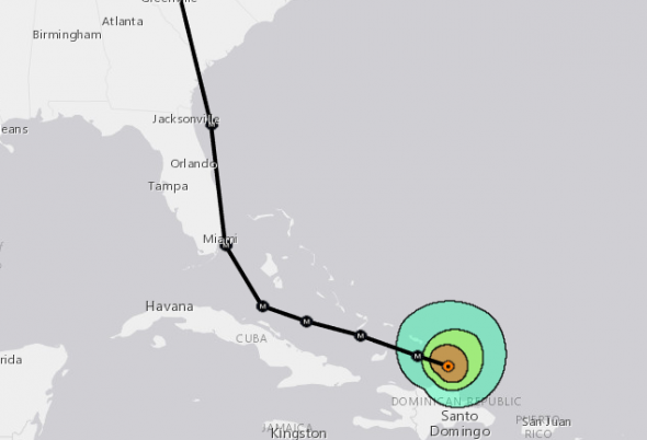
When to Expect Hurricane Irma and Where
INIT 07/1500Z 20.4N 69.7W 150 KT 175 MPH
12H 08/0000Z 21.1N 71.7W 145 KT 165 MPH – 35 miles south-southwest of Turks and Caicos
24H 08/1200Z 21.9N 74.2W 140 KT 160 MPH – 99 miles NNE of Moa, Cuba
36H 09/0000Z 22.5N 76.5W 135 KT 155 MPH – 110 miles SE of The Bahamas
48H 09/1200Z 23.1N 78.4W 135 KT 155 MPH – 42 miles North of Cayo Coco, Cuba
72H 10/1200Z 25.5N 80.0W 125 KT 145 MPH – 21 miles SE of Miami
75 H 10/1500Z —- landfall Florida —– Pompano Beach
96H 11/1200Z 30.1N 80.6W 105 KT 120 MPH – 48 miles east of Jacksonville Beach, Florida
—- landfall Georgia —–
120H 12/1200Z 35.0N 82.0W 50 KT 60 MPH…INLAND – Spartanburg, SC


In prayer, I heard this word. “Nothing eternal is being washed away’. This was before there had been any fatalities. In the light of eternity, what matters?